Klundert night lights from space
Night Light of Klundert (North Brabant) from space (Netherlands) Src. Average luminocity for 10x10km area is 30.3291% and for 50x50km: 27.2309%.
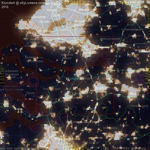
Analysis of Klundert night lights 2016
Square area 10x10 km:
 8.54%
8.54%90-99
7.42%80-89
2.24%70-79
0.84%60-69
3.78%50-59
1.82%40-49
1.68%30-39
0.7%20-29
9.66%10-19
25.35%0-9
37.96%Square area 50x50 km:
6.09%90-99
5.85%80-89
2.37%70-79
2.15%60-69
2.47%50-59
2.59%40-49
2.34%30-39
4.46%20-29
8.09%10-19
21.18%0-9
42.42%Clear (daylight) street map image can be seen on geolist.org.
Map coordinates:
52° 5' 56.5" North, 3° 49' 53.7" East
51° 39' 54" North, 4° 32' 5" East
51° 13' 36.4" North, 5° 14' 16.2" East
Some cities around Klundert sort by population:
• Roosendaal
15.7 km =9.8 mi,  197°
197°
• Prinsenbeek
14.3 km =8.9 mi,  121°
121°
• Strijen
9 km =5.6 mi,  7°
7°
• Sint Willebrord
13.5 km =8.4 mi,  163°
163°
• Princenhage
17.2 km =10.7 mi, 124°
• Terheijden
15.3 km =9.5 mi,  99°
99°
• Oud Gastel
10.1 km =6.3 mi,  210°
210°
• Dinteloord
11.9 km =7.4 mi,  253°
253°
2752600 (p: 5,405)
Sources (retrieved 2019-11-25):
» Earth at Night: Flat Maps 2012, 2016