Prinsenbeek night lights from space
Night Light of Prinsenbeek (North Brabant) from space (Netherlands) Src. Average luminocity for 10x10km area is 50.0334% and for 50x50km: 23.4066%.
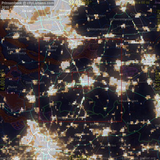
Analysis of Prinsenbeek night lights 2016
Square area 10x10 km:
 12.97%
90-99
13.64%80-89
3.61%70-79
4.01%60-69
4.81%50-59
4.95%40-49
2.94%30-39
6.28%20-29
19.12%10-19
27.01%0-9
0.67%Square area 50x50 km:
3.98%90-99
4.38%80-89
1.98%70-79
1.75%60-69
1.97%50-59
2.16%40-49
2.62%30-39
4.03%20-29
9.34%10-19
23.86%0-9
43.93%Clear (daylight) street map image can be seen on geolist.org.
Map coordinates:
52° 1' 58.8" North, 4° 0' 33.8" East
51° 35' 54" North, 4° 42' 45" East
51° 9' 34.1" North, 5° 24' 56.3" East
Some cities around Prinsenbeek sort by population:
• Breda
4.6 km =2.9 mi,  106°
106°
• Hoge Vucht
5.6 km =3.5 mi,  78°
78°
• Princenhage
3.1 km =1.9 mi,  143°
143°
• Teteringen
7.6 km =4.7 mi, 80°
• Terheijden
5.8 km =3.6 mi,  29°
29°
• Ginneken
6.6 km =4.1 mi,  122°
122°
• Zandberg
5.7 km =3.5 mi, 119°
• Heusdenhout
7.5 km =4.7 mi,  98°
98°
2748448 (p: 10,720)
Sources (retrieved 2019-11-25):
» Earth at Night: Flat Maps 2012, 2016