Dinteloord night lights from space
Night Light of Dinteloord (North Brabant) from space (Netherlands) Src. Average luminocity for 10x10km area is 8.9412% and for 50x50km: 19.0746%.
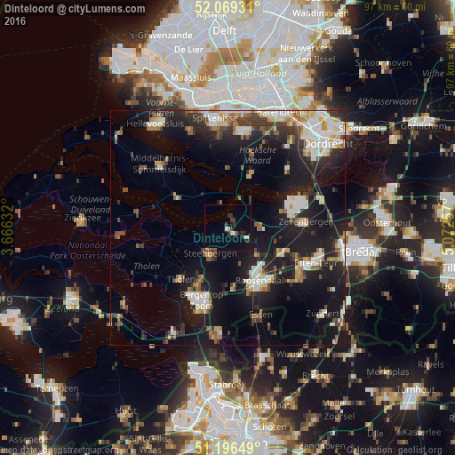
Analysis of Dinteloord night lights 2016
Square area 10x10 km:
 0.84%
0.84%90-99
0.84%80-89
0.42%70-79
1.26%60-69
0.7%50-59
0.56%40-49
1.26%30-39
2.94%20-29
2.1%10-19
3.5%0-9
85.57%Square area 50x50 km:
3.09%90-99
3.49%80-89
1.76%70-79
1.58%60-69
2.15%50-59
2.29%40-49
1.92%30-39
3.27%20-29
5.78%10-19
18.4%0-9
56.27%Clear (daylight) street map image can be seen on geolist.org.
Map coordinates:
52° 4' 9.5" North, 3° 39' 58.8" East
51° 38' 6" North, 4° 22' 10" East
51° 11' 47.4" North, 5° 4' 21.3" East
Some cities around Dinteloord sort by population:
• Roosendaal
13.3 km =8.3 mi,  150°
150°
• Bergen op Zoom
16.5 km =10.3 mi,  199°
199°
• Steenbergen
6.6 km =4.1 mi,  211°
211°
• Halsteren
13.8 km =8.6 mi, 210°
• Strijen
17.5 km =10.9 mi,  45°
45°
• Tholen
15.4 km =9.6 mi,  221°
221°
• Klundert
11.9 km =7.4 mi,  73°
73°
• Oud Gastel
8.2 km =5.1 mi,  130°
130°
2756800 (p: 5,105)
Sources (retrieved 2019-11-25):
» Earth at Night: Flat Maps 2012, 2016