Velp night lights from space
Night Light of Velp (Gelderland) from space (Netherlands) Src. Average luminocity for 10x10km area is 47.0164% and for 50x50km: 18.8501%.
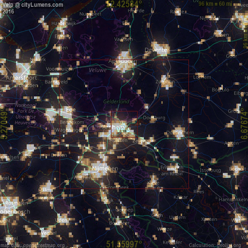
Analysis of Velp night lights 2016
Square area 10x10 km:
100  9.22%
9.22%
90-99 8.96%
80-89 6.44%
70-79 6.44%
60-69 7.2%
50-59 6.94%
40-49 4.42%
30-39 5.18%
20-29 12.63%
10-19 22.22%
0-9 10.35%
9.22%90-99
8.96%80-89
6.44%70-79
6.44%60-69
7.2%50-59
6.94%40-49
4.42%30-39
5.18%20-29
12.63%10-19
22.22%0-9
10.35%Square area 50x50 km:
100 2.45%
90-99 3.1%
80-89 2.11%
70-79 1.86%
60-69 2.5%
50-59 2.48%
40-49 2.29%
30-39 2.6%
20-29 6.14%
10-19 17.13%
0-9 57.32%
2.45%90-99
3.1%80-89
2.11%70-79
1.86%60-69
2.5%50-59
2.48%40-49
2.29%30-39
2.6%20-29
6.14%10-19
17.13%0-9
57.32%Clear (daylight) street map image can be seen on geolist.org.
Map coordinates:
52° 25' 33" North, 5° 16' 13.8" East
51° 59' 42" North, 5° 58' 25" East
51° 33' 35.9" North, 6° 40' 36.3" East
Some cities around Velp sort by population:
• Arnhem
4.6 km =2.9 mi,  248°
248°
• Zevenaar
9.8 km =6.1 mi,  137°
137°
• Duiven
6 km =3.7 mi,  152°
152°
• Dieren
10.8 km =6.7 mi,  53°
53°
• Doesburg
11.5 km =7.1 mi,  80°
80°
• Oosterbeek
8.8 km =5.5 mi,  263°
263°
• Rheden
4 km =2.5 mi,  73°
73°
• Westervoort
4.4 km =2.7 mi,  181°
181°
2745677 (p: 17,669)
Sources (retrieved 2019-11-25):
» Earth at Night: Flat Maps 2012, 2016