Bunnik night lights from space
Night Light of Bunnik (Utrecht) from space (Netherlands) Src. Average luminocity for 10x10km area is 57.5331% and for 50x50km: 24.4523%.
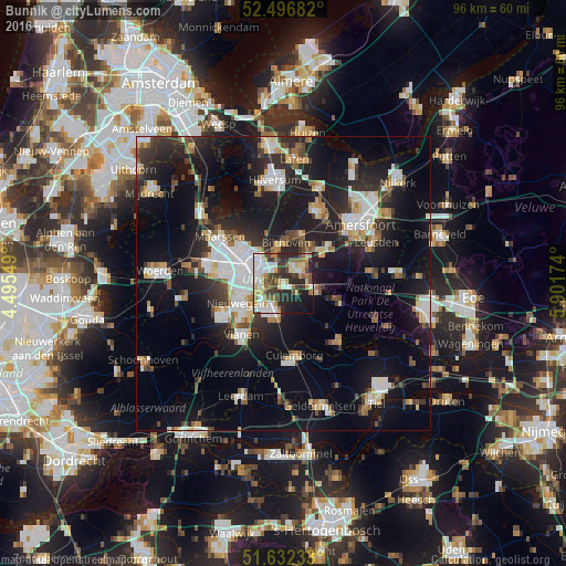
Analysis of Bunnik night lights 2016
Square area 10x10 km:
 13.89%
90-99
11.9%80-89
8.07%70-79
6.88%60-69
6.22%50-59
7.14%40-49
7.41%30-39
10.45%20-29
15.61%10-19
10.71%0-9
1.72%Square area 50x50 km:
4.55%90-99
4.47%80-89
2.24%70-79
2.16%60-69
2.35%50-59
2.3%40-49
2.88%30-39
3.48%20-29
8.14%10-19
20.99%0-9
46.46%Clear (daylight) street map image can be seen on geolist.org.
Map coordinates:
52° 29' 48.6" North, 4° 29' 43.8" East
52° 4' 0" North, 5° 11' 55" East
51° 37' 56.4" North, 5° 54' 6.3" East
Some cities around Bunnik sort by population:
• Utrecht
5.9 km =3.7 mi,  297°
297°
• Nieuwegein
9.1 km =5.7 mi,  242°
242°
• Zeist
3.5 km =2.2 mi,  42°
42°
• Driebergen-Rijsenburg
5.8 km =3.6 mi,  104°
104°
• Lunetten
4.4 km =2.7 mi,  262°
262°
• Doorn
10.7 km =6.6 mi,  110°
110°
• De Bilt
5 km =3.1 mi,  345°
345°
• Odijk
3 km =1.9 mi,  121°
121°
2758106 (p: 6,315)
Sources (retrieved 2019-11-25):
» Earth at Night: Flat Maps 2012, 2016