Abak night lights from space
Night Light of Abak (Akwa Ibom) from space (Nigeria) Src. Average luminocity for 10x10km area is 0% and for 50x50km: 2.2017%.
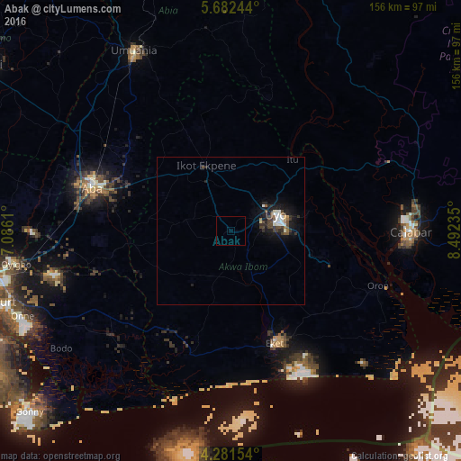
Analysis of Abak night lights 2016
Square area 10x10 km:
100  0%
0%
90-99 0%
80-89 0%
70-79 0%
60-69 0%
50-59 0%
40-49 0%
30-39 0%
20-29 0%
10-19 0%
0-9 100%
0%90-99
0%80-89
0%70-79
0%60-69
0%50-59
0%40-49
0%30-39
0%20-29
0%10-19
0%0-9
100%Square area 50x50 km:
100 0.27%
90-99 0.44%
80-89 0.13%
70-79 0.1%
60-69 0.15%
50-59 0.21%
40-49 0.51%
30-39 0.53%
20-29 0.6%
10-19 2.19%
0-9 94.87%
0.27%90-99
0.44%80-89
0.13%70-79
0.1%60-69
0.15%50-59
0.21%40-49
0.51%30-39
0.53%20-29
0.6%10-19
2.19%0-9
94.87%Clear (daylight) street map image can be seen on geolist.org.
Map coordinates:
5° 40' 56.8" North, 7° 5' 10" East
4° 58' 56.5" North, 7° 47' 21.2" East
4° 16' 53.5" North, 8° 29' 32.5" East
Some cities around Abak sort by population:
• Aba
48.8 km =30.3 mi,  286°
286°
• Uyo
17.7 km =11 mi,  64°
64°
• Ikot Ekpene
23.7 km =14.7 mi,  339°
339°
• Itu
32.5 km =20.2 mi,  41°
41°
• Eket
40.7 km =25.3 mi,  158°
158°
• Arochukwu
47.3 km =29.4 mi,  16°
16°
• Etinan
17 km =10.6 mi, 155°
• Akankpa
47.2 km =29.3 mi,  70°
70°
2353100 (p: 12,562)
Sources (retrieved 2019-11-25):
» Earth at Night: Flat Maps 2012, 2016