Zitlaltépec night lights from space
Night Light of Zitlaltépec (Tlaxcala) from space (Mexico) Src. Average luminocity for 10x10km area is 17.0779% and for 50x50km: 24.7399%.
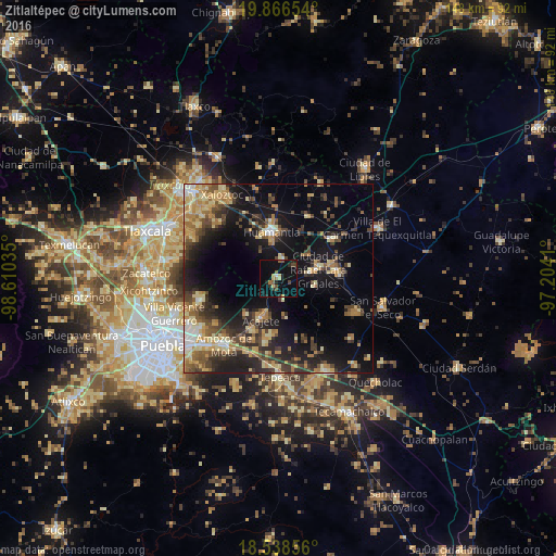
Analysis of Zitlaltépec night lights 2016
Square area 10x10 km:
 0.65%
0.65%90-99
0.43%80-89
3.25%70-79
1.3%60-69
2.16%50-59
3.46%40-49
3.46%30-39
1.08%20-29
4.55%10-19
14.72%0-9
64.94%Square area 50x50 km:
1.2%90-99
2%80-89
5.36%70-79
3.85%60-69
3.97%50-59
3.32%40-49
5.43%30-39
4.68%20-29
6.74%10-19
17.37%0-9
46.06%Clear (daylight) street map image can be seen on geolist.org.
Map coordinates:
19° 51' 59.5" North, 98° 36' 37.3" West
19° 12' 14" North, 97° 54' 26" West
18° 32' 18.8" North, 97° 12' 14.8" West
Some cities around Zitlaltépec sort by population:
• Huamantla
12.4 km =7.7 mi,  351°
351°
• Acajete
11.3 km =7 mi,  204°
204°
• Grajales
11.3 km =7 mi,  76°
76°
• Santa María Ixtiyucán
10.3 km =6.4 mi,  100°
100°
• Ignacio Zaragoza
9.9 km =6.2 mi, 351°
• Nopalucán
9 km =5.6 mi, 79°
• Ixtenco
5.5 km =3.4 mi,  14°
14°
• El Rincón Citlaltépetl
5.5 km =3.4 mi,  165°
165°
3815329 (p: 6,280)
Sources (retrieved 2019-11-25):
» Earth at Night: Flat Maps 2012, 2016