Zimapan night lights from space
Night Light of Zimapan (Hidalgo) from space (Mexico) Src. Average luminocity for 10x10km area is 16.7443% and for 50x50km: 2.2932%.
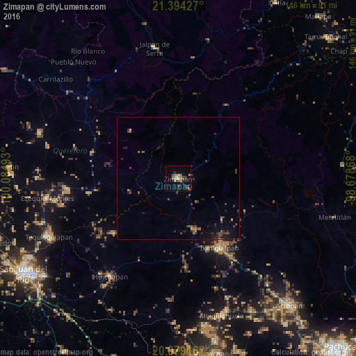
Analysis of Zimapan night lights 2016
Square area 10x10 km:
 0.57%
0.57%90-99
0.95%80-89
1.33%70-79
2.84%60-69
3.41%50-59
4.36%40-49
4.55%30-39
2.65%20-29
3.98%10-19
1.7%0-9
73.67%Square area 50x50 km:
0.02%90-99
0.07%80-89
0.12%70-79
0.22%60-69
0.33%50-59
0.52%40-49
0.81%30-39
0.59%20-29
0.84%10-19
1.2%0-9
95.28%Clear (daylight) street map image can be seen on geolist.org.
Map coordinates:
21° 23' 39.4" North, 100° 5' 5.7" West
20° 44' 17.3" North, 99° 22' 54.5" West
20° 4' 45" North, 98° 40' 43.2" West
Some cities around Zimapan sort by population:
• Ixmiquilpan
33.6 km =20.9 mi,  149°
149°
• Progreso de Alvaro Obregon
57.9 km =36 mi,  159°
159°
• Ezequiel Montes
54.5 km =33.9 mi,  261°
261°
• Cadereyta
45.4 km =28.2 mi, 264°
• Jalpan
54.2 km =33.7 mi,  350°
350°
• Huichapan
48.9 km =30.4 mi,  214°
214°
• Tecozautla
34.8 km =21.6 mi,  229°
229°
• Villa Progreso
48.3 km =30 mi, 257°
3514031 (p: 13,243)
Sources (retrieved 2019-11-25):
» Earth at Night: Flat Maps 2012, 2016