Zaragoza night lights from space
Night Light of Zaragoza (Puebla) from space (Mexico) Src. Average luminocity for 10x10km area is 17.6364% and for 50x50km: 8.1074%.
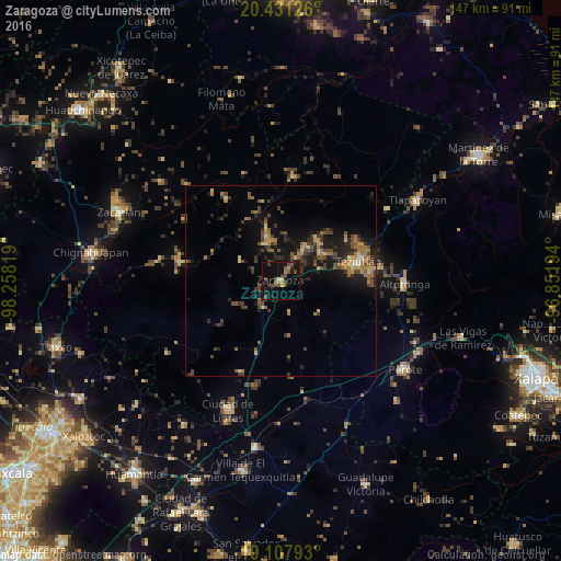
Analysis of Zaragoza night lights 2016
Square area 10x10 km:
 0%
0%90-99
0.41%80-89
0.62%70-79
1.65%60-69
3.1%50-59
2.89%40-49
9.71%30-39
4.13%20-29
2.27%10-19
19.21%0-9
55.99%Square area 50x50 km:
0.08%90-99
0.22%80-89
0.84%70-79
1.06%60-69
1.8%50-59
1.26%40-49
2.69%30-39
1.95%20-29
2.33%10-19
6.99%0-9
80.78%Clear (daylight) street map image can be seen on geolist.org.
Map coordinates:
20° 25' 52.5" North, 98° 15' 29.5" West
19° 46' 15.5" North, 97° 33' 18.2" West
19° 6' 28.5" North, 96° 51' 7" West
Some cities around Zaragoza sort by population:
• Teziutlan
21.1 km =13.1 mi,  75°
75°
• Chinautla
18.2 km =11.3 mi,  72°
72°
• Tlatlauquitepec
10.5 km =6.5 mi,  35°
35°
• Ciudad de Tlatlauquitepec
11 km =6.8 mi,  34°
34°
• Zacapoaxtla
11.9 km =7.4 mi,  342°
342°
• Atempan
12.6 km =7.8 mi,  52°
52°
• Hueyapán
16.9 km =10.5 mi, 42°
• Atoluca
23.1 km =14.4 mi, 66°
3514051 (p: 10,743)
Sources (retrieved 2019-11-25):
» Earth at Night: Flat Maps 2012, 2016