Ciudad de Tlatlauquitepec night lights from space
Night Light of Ciudad de Tlatlauquitepec (Puebla) from space (Mexico) Src. Average luminocity for 10x10km area is 29.3658% and for 50x50km: 9.1235%.
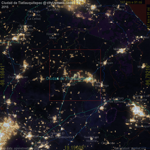
Analysis of Ciudad de Tlatlauquitepec night lights 2016
Square area 10x10 km:
 0%
0%90-99
0.65%80-89
3.68%70-79
5.84%60-69
4.76%50-59
4.76%40-49
9.31%30-39
10.17%20-29
8.01%10-19
36.8%0-9
16.02%Square area 50x50 km:
0.08%90-99
0.22%80-89
0.95%70-79
1.12%60-69
1.93%50-59
1.26%40-49
2.97%30-39
2.53%20-29
2.9%10-19
8.42%0-9
77.62%Clear (daylight) street map image can be seen on geolist.org.
Map coordinates:
20° 30' 45.8" North, 98° 11' 54.3" West
19° 51' 10" North, 97° 29' 43" West
19° 11' 24.3" North, 96° 47' 31.8" West
Some cities around Ciudad de Tlatlauquitepec sort by population:
• Teziutlan
14.7 km =9.1 mi,  105°
105°
• Chinautla
11.7 km =7.3 mi, 108°
• Zaragoza
11 km =6.8 mi,  214°
214°
• Tlatlauquitepec
0.6 km =0.4 mi,  199°
199°
• Zacapoaxtla
10 km =6.2 mi,  282°
282°
• Atempan
4.1 km =2.5 mi, 111°
• Hueyapán
6.2 km =3.9 mi,  57°
57°
• Atoluca
14.8 km =9.2 mi,  89°
89°
3818673 (p: 9,047)
Sources (retrieved 2019-11-25):
» Earth at Night: Flat Maps 2012, 2016