Villa del Campo night lights from space
Night Light of Villa del Campo (Baja California) from space (Mexico) Src. Average luminocity for 10x10km area is 35.1374% and for 50x50km: 20.1688%.
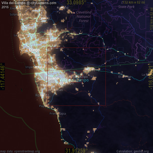
Analysis of Villa del Campo night lights 2016
Square area 10x10 km:
 0.73%
0.73%90-99
3.3%80-89
1.47%70-79
2.56%60-69
11.36%50-59
10.99%40-49
7.14%30-39
10.81%20-29
12.64%10-19
33.15%0-9
5.86%Square area 50x50 km:
4.23%90-99
4.08%80-89
1.37%70-79
1.75%60-69
4.23%50-59
3.33%40-49
3.07%30-39
2.04%20-29
3.63%10-19
9.21%0-9
63.05%Clear (daylight) street map image can be seen on geolist.org.
Map coordinates:
33° 5' 54.6" North, 117° 26' 29.3" West
32° 30' 27" North, 116° 44' 18" West
31° 54' 45.3" North, 116° 2' 6.8" West
Some cities around Villa del Campo sort by population:
• Tijuana
24.9 km =15.5 mi,  268°
268°
• Tecate
12.5 km =7.8 mi,  57°
57°
• Terrazas del Valle
8.6 km =5.3 mi,  254°
254°
• Las Delicias
22.2 km =13.8 mi,  240°
240°
• El Niño
5 km =3.1 mi, 270°
• San Luis
21.9 km =13.6 mi, 247°
• Maclovio Rojas
7.2 km =4.5 mi, 237°
• Lomas de Santa Anita
9 km =5.6 mi, 64°
8858130 (p: 13,906)
Sources (retrieved 2019-11-25):
» Earth at Night: Flat Maps 2012, 2016