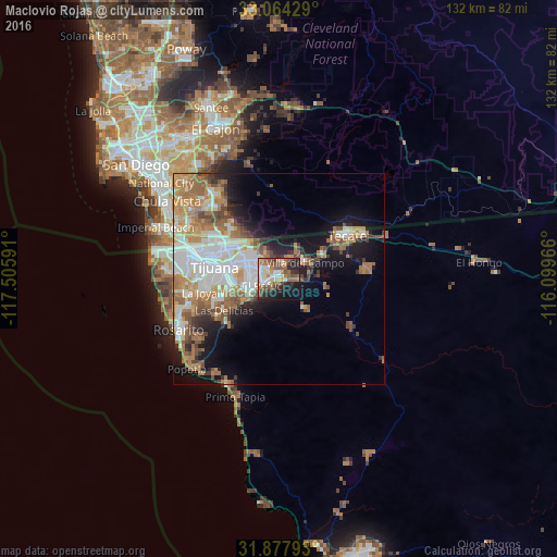
Maclovio Rojas night lights from space
Night Light of Maclovio Rojas (Baja California) from space (Mexico) Src. Average luminocity for 10x10km area is 52.0092% and for 50x50km: 27.6982%.
Analysis of Maclovio Rojas night lights 2016
Square area 10x10 km:
 7.33%
7.33%90-99
13.37%80-89
3.3%70-79
4.03%60-69
11.17%50-59
11.9%40-49
8.24%30-39
7.51%20-29
15.75%10-19
14.65%0-9
2.75%Square area 50x50 km:
5.88%90-99
5.73%80-89
2.23%70-79
3.76%60-69
6.64%50-59
3.91%40-49
3.16%30-39
2.25%20-29
3.63%10-19
9.38%0-9
53.43%Clear (daylight) street map image can be seen on geolist.org.
Map coordinates:
33° 3' 51.4" North, 117° 30' 21.3" West
32° 28' 23" North, 116° 48' 10" West
31° 52' 40.5" North, 116° 5' 58.8" West
Some cities around Maclovio Rojas sort by population:
• Rancho La Gloria
18.8 km =11.7 mi,  260°
260°
• Terrazas del Valle
2.8 km =1.7 mi,  305°
305°
• Villa del Prado 2da Sección
16.8 km =10.4 mi,  250°
250°
• Las Delicias
15 km =9.3 mi,  241°
241°
• Villa del Campo
7.2 km =4.5 mi,  57°
57°
• El Niño
4 km =2.5 mi,  14°
14°
• San Luis
14.9 km =9.3 mi, 251°
• Lomas de Santa Anita
16.2 km =10.1 mi, 61°
8858197 (p: 7,279)
Sources (retrieved 2019-11-25):
» Earth at Night: Flat Maps 2012, 2016