Vicente Guerrero night lights from space
Night Light of Vicente Guerrero (Durango) from space (Mexico) Src. Average luminocity for 10x10km area is 10.5397% and for 50x50km: 1.7991%.
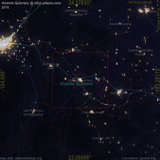
Analysis of Vicente Guerrero night lights 2016
Square area 10x10 km:
 0%
0%90-99
1.19%80-89
3.37%70-79
2.98%60-69
0.79%50-59
0.4%40-49
0.4%30-39
2.18%20-29
1.59%10-19
0.2%0-9
86.9%Square area 50x50 km:
0%90-99
0.16%80-89
0.33%70-79
0.37%60-69
0.13%50-59
0.17%40-49
0.51%30-39
0.58%20-29
0.45%10-19
0.32%0-9
96.99%Clear (daylight) street map image can be seen on geolist.org.
Map coordinates:
24° 22' 34.9" North, 104° 41' 16.8" West
23° 44' 3.4" North, 103° 59' 5.5" West
23° 5' 20.6" North, 103° 16' 54.3" West
Some cities around Vicente Guerrero sort by population:
• Victoria de Durango
75.4 km =46.9 mi,  294°
294°
• Sombrerete
36.6 km =22.7 mi,  107°
107°
• Ciudad Guadalupe Victoria
80.1 km =49.8 mi,  350°
350°
• Juan Aldama
86.4 km =53.7 mi,  44°
44°
• Miguel Auza
82.6 km =51.3 mi, 41°
• Villa Unión
27.5 km =17.1 mi, 346°
• Nombre de Dios
29.6 km =18.4 mi,  295°
295°
• Sain Alto
77 km =47.8 mi,  102°
102°
4005857 (p: 15,982)
Sources (retrieved 2019-11-25):
» Earth at Night: Flat Maps 2012, 2016