Venustiano Carranza night lights from space
Night Light of Venustiano Carranza (Chiapas) from space (Mexico) Src. Average luminocity for 10x10km area is 7.0393% and for 50x50km: 2.2746%.
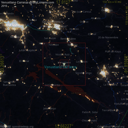
Analysis of Venustiano Carranza night lights 2016
Square area 10x10 km:
 0.41%
0.41%90-99
1.24%80-89
0.83%70-79
1.65%60-69
0.83%50-59
0.83%40-49
0.83%30-39
1.65%20-29
0.21%10-19
1.86%0-9
89.67%Square area 50x50 km:
0.06%90-99
0.41%80-89
0.34%70-79
0.4%60-69
0.28%50-59
0.24%40-49
0.47%30-39
0.5%20-29
0.36%10-19
0.21%0-9
96.74%Clear (daylight) street map image can be seen on geolist.org.
Map coordinates:
17° 0' 42.1" North, 93° 15' 58.1" West
16° 20' 17.3" North, 92° 33' 46.8" West
15° 39' 44.2" North, 91° 51' 35.6" West
Some cities around Venustiano Carranza sort by population:
• San Cristóbal de las Casas
44.6 km =27.7 mi,  349°
349°
• Las Rosas
20.8 km =12.9 mi,  81°
81°
• Teopisca
24.6 km =15.3 mi,  22°
22°
• Acala
35.4 km =22 mi,  313°
313°
• La Concordia
28 km =17.4 mi,  208°
208°
• San Francisco Pujiltic
13.4 km =8.3 mi,  119°
119°
• Chanal
45.5 km =28.3 mi, 22°
• Tzimol
43.4 km =27 mi,  113°
113°
3514785 (p: 15,496)
Sources (retrieved 2019-11-25):
» Earth at Night: Flat Maps 2012, 2016