Pedro Amaro night lights from space
Night Light of Pedro Amaro (Morelos) from space (Mexico) Src. Average luminocity for 10x10km area is 40.2273% and for 50x50km: 17.0853%.
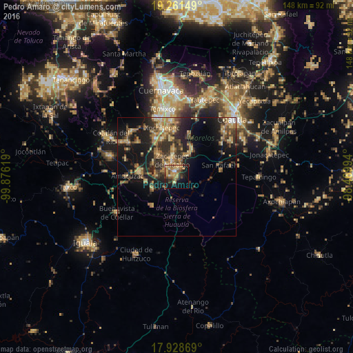
Analysis of Pedro Amaro night lights 2016
Square area 10x10 km:
 1.45%
1.45%90-99
2.07%80-89
8.88%70-79
8.26%60-69
12.19%50-59
8.47%40-49
4.55%30-39
6.61%20-29
7.64%10-19
24.17%0-9
15.7%Square area 50x50 km:
0.38%90-99
0.76%80-89
3.24%70-79
3.28%60-69
3.99%50-59
2.3%40-49
3.63%30-39
3.72%20-29
5.43%10-19
13.35%0-9
59.92%Clear (daylight) street map image can be seen on geolist.org.
Map coordinates:
19° 15' 41.4" North, 99° 52' 34.3" West
18° 35' 47" North, 99° 10' 23" West
17° 55' 43.3" North, 98° 28' 11.8" West
Some cities around Pedro Amaro sort by population:
• Zacatepec
6.7 km =4.2 mi,  344°
344°
• Jojutla
2.2 km =1.4 mi, 339°
• Tlaquiltenango
4.3 km =2.7 mi,  13°
13°
• Santa Rosa Treinta
11.6 km =7.2 mi,  354°
354°
• Galeana
6.2 km =3.9 mi,  318°
318°
• Tlaltizapán
11.5 km =7.1 mi,  29°
29°
• Tehuixtla
11.1 km =6.9 mi,  248°
248°
• Tlatenchi
1.4 km =0.9 mi,  270°
270°
8858250 (p: 5,551)
Sources (retrieved 2019-11-25):
» Earth at Night: Flat Maps 2012, 2016