Cherán night lights from space
Night Light of Cherán (Michoacán) from space (Mexico) Src. Average luminocity for 10x10km area is 7.8884% and for 50x50km: 4.983%.
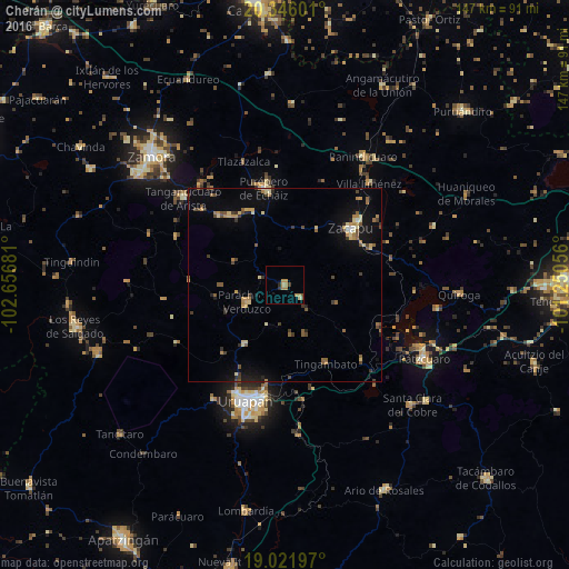
Analysis of Cherán night lights 2016
Square area 10x10 km:
 0%
0%90-99
0.21%80-89
0.62%70-79
2.27%60-69
4.34%50-59
0.41%40-49
0.62%30-39
0.83%20-29
1.45%10-19
0%0-9
89.26%Square area 50x50 km:
0.06%90-99
0.27%80-89
0.89%70-79
0.71%60-69
0.9%50-59
0.84%40-49
0.9%30-39
0.86%20-29
0.51%10-19
2.69%0-9
91.37%Clear (daylight) street map image can be seen on geolist.org.
Map coordinates:
20° 20' 45.6" North, 102° 39' 24.5" West
19° 41' 7.3" North, 101° 57' 13.2" West
19° 1' 19.1" North, 101° 15' 2" West
Some cities around Cherán sort by population:
• Zacapu
22.9 km =14.2 mi,  48°
48°
• Zacapú
22.2 km =13.8 mi, 49°
• Paracho de Verduzco
10.8 km =6.7 mi,  247°
247°
• Nahuatzén
5.1 km =3.2 mi,  131°
131°
• Tingambato
23 km =14.3 mi,  152°
152°
• Chilchota
24.8 km =15.4 mi,  316°
316°
• Capácuaro
18.5 km =11.5 mi,  213°
213°
• Carapán
21.3 km =13.2 mi,  335°
335°
4014409 (p: 14,245)
Sources (retrieved 2019-11-25):
» Earth at Night: Flat Maps 2012, 2016