Tesechoacan night lights from space
Night Light of Tesechoacan (Veracruz) from space (Mexico) Src. Average luminocity for 10x10km area is 1.1017% and for 50x50km: 2.0263%.
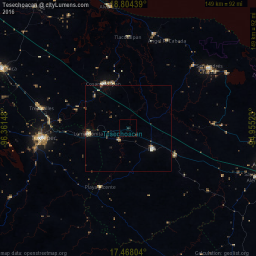
Analysis of Tesechoacan night lights 2016
Square area 10x10 km:
 0%
0%90-99
0%80-89
0%70-79
0%60-69
0%50-59
0%40-49
0.87%30-39
0.87%20-29
0.87%10-19
0%0-9
97.4%Square area 50x50 km:
0.02%90-99
0.47%80-89
0.24%70-79
0.19%60-69
0.1%50-59
0.25%40-49
0.33%30-39
0.59%20-29
0.36%10-19
0.68%0-9
96.76%Clear (daylight) street map image can be seen on geolist.org.
Map coordinates:
18° 48' 15.8" North, 96° 21' 41.3" West
18° 8' 15" North, 95° 39' 30.1" West
17° 28' 4.9" North, 94° 57' 18.8" West
Some cities around Tesechoacan sort by population:
• Tuxtepec
49.7 km =30.9 mi,  263°
263°
• Loma Bonita
23.6 km =14.7 mi, 261°
• Cosamaloapan
29.6 km =18.4 mi,  329°
329°
• Isla
18.3 km =11.4 mi,  131°
131°
• Carlos A. Carrillo
28.3 km =17.6 mi,  338°
338°
• Juan Rodríguez Clara
31.6 km =19.6 mi,  120°
120°
• Playa Vicente
37.7 km =23.4 mi,  205°
205°
• Villa Azueta
9.1 km =5.7 mi,  218°
218°
3514686 (p: 6,783)
Sources (retrieved 2019-11-25):
» Earth at Night: Flat Maps 2012, 2016