Tenabo night lights from space
Night Light of Tenabo (Campeche) from space (Mexico) Src. Average luminocity for 10x10km area is 9.4921% and for 50x50km: 2.4303%.
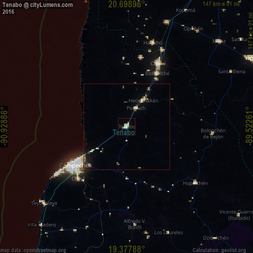
Analysis of Tenabo night lights 2016
Square area 10x10 km:
 0.6%
0.6%90-99
2.78%80-89
3.37%70-79
0.4%60-69
0.79%50-59
0%40-49
0%30-39
0%20-29
1.59%10-19
0%0-9
90.48%Square area 50x50 km:
0.02%90-99
0.43%80-89
0.54%70-79
0.22%60-69
0.19%50-59
0.29%40-49
0.35%30-39
0.52%20-29
0.46%10-19
1.02%0-9
95.96%Clear (daylight) street map image can be seen on geolist.org.
Map coordinates:
20° 41' 56.3" North, 90° 55' 43.9" West
20° 2' 23.3" North, 90° 13' 32.6" West
19° 22' 40.4" North, 89° 31' 21.4" West
Some cities around Tenabo sort by population:
• Campeche
38.2 km =23.7 mi,  235°
235°
• Calkiní
40.9 km =25.4 mi,  26°
26°
• Dzitbalché
35.7 km =22.2 mi, 29°
• Hecelchakán
18.1 km =11.2 mi, 32°
• Pomuch
12.1 km =7.5 mi, 26°
• Lerma
47.2 km =29.3 mi, 236°
• Nunkiní
40.9 km =25.4 mi,  11°
11°
• Chiná
41.2 km =25.6 mi,  223°
223°
3516017 (p: 7,543)
Sources (retrieved 2019-11-25):
» Earth at Night: Flat Maps 2012, 2016