Dzitbalché night lights from space
Night Light of Dzitbalché (Campeche) from space (Mexico) Src. Average luminocity for 10x10km area is 22.9621% and for 50x50km: 4.3609%.
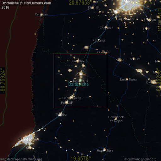
Analysis of Dzitbalché night lights 2016
Square area 10x10 km:
 0.76%
0.76%90-99
5.49%80-89
5.11%70-79
0.19%60-69
2.27%50-59
2.84%40-49
3.03%30-39
0.76%20-29
5.68%10-19
33.14%0-9
40.72%Square area 50x50 km:
0.16%90-99
0.73%80-89
1.05%70-79
0.38%60-69
0.45%50-59
0.33%40-49
0.54%30-39
0.62%20-29
0.55%10-19
2.96%0-9
92.23%Clear (daylight) street map image can be seen on geolist.org.
Map coordinates:
20° 58' 35.5" North, 90° 45' 33.3" West
20° 19' 6.9" North, 90° 3' 22" West
19° 39' 28.1" North, 89° 21' 10.8" West
Some cities around Dzitbalché sort by population:
• Calkiní
5.6 km =3.5 mi,  5°
5°
• Maxcanú
30.1 km =18.7 mi, 10°
• Hecelchakán
17.7 km =11 mi,  207°
207°
• Halachó
17.9 km =11.1 mi,  351°
351°
• Pomuch
23.7 km =14.7 mi, 211°
• Tenabo
35.7 km =22.2 mi, 209°
• Bécal
14 km =8.7 mi, 12°
• Nunkiní
13.2 km =8.2 mi,  313°
313°
3529650 (p: 11,686)
Sources (retrieved 2019-11-25):
» Earth at Night: Flat Maps 2012, 2016