Pomuch night lights from space
Night Light of Pomuch (Campeche) from space (Mexico) Src. Average luminocity for 10x10km area is 11.5437% and for 50x50km: 2.7744%.
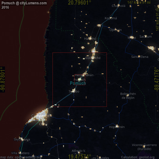
Analysis of Pomuch night lights 2016
Square area 10x10 km:
 0%
0%90-99
2.78%80-89
3.57%70-79
0%60-69
0.79%50-59
0.6%40-49
2.38%30-39
2.98%20-29
0.4%10-19
1.19%0-9
85.32%Square area 50x50 km:
0.04%90-99
0.56%80-89
0.73%70-79
0.2%60-69
0.22%50-59
0.23%40-49
0.39%30-39
0.35%20-29
0.38%10-19
1.44%0-9
95.46%Clear (daylight) street map image can be seen on geolist.org.
Map coordinates:
20° 47' 45.6" North, 90° 52' 40.8" West
20° 8' 14.2" North, 90° 10' 29.6" West
19° 28' 32.7" North, 89° 28' 18.3" West
Some cities around Pomuch sort by population:
• Campeche
49.1 km =30.5 mi,  228°
228°
• Calkiní
28.8 km =17.9 mi,  26°
26°
• Dzitbalché
23.7 km =14.7 mi, 31°
• Hecelchakán
6.2 km =3.9 mi,  44°
44°
• Halachó
39.1 km =24.3 mi,  14°
14°
• Tenabo
12.1 km =7.5 mi,  206°
206°
• Bécal
37.2 km =23.1 mi,  24°
24°
• Nunkiní
29.4 km =18.3 mi, 5°
3521283 (p: 8,694)
Sources (retrieved 2019-11-25):
» Earth at Night: Flat Maps 2012, 2016