Quesería night lights from space
Night Light of Quesería (Colima) from space (Mexico) Src. Average luminocity for 10x10km area is 9.1488% and for 50x50km: 7.9233%.
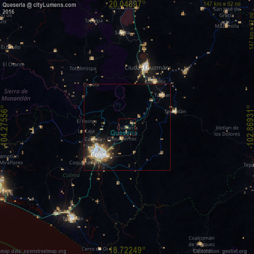
Analysis of Quesería night lights 2016
Square area 10x10 km:
 0%
0%90-99
0%80-89
1.86%70-79
2.89%60-69
0.62%50-59
1.03%40-49
3.1%30-39
2.27%20-29
0.62%10-19
1.24%0-9
86.36%Square area 50x50 km:
1.15%90-99
0.92%80-89
1.05%70-79
1.54%60-69
0.91%50-59
0.73%40-49
1.19%30-39
1.59%20-29
2.06%10-19
3.95%0-9
84.93%Clear (daylight) street map image can be seen on geolist.org.
Map coordinates:
20° 2' 56.3" North, 104° 16' 32" West
19° 23' 13.5" North, 103° 34' 20.7" West
18° 43' 21" North, 102° 52' 9.5" West
Some cities around Quesería sort by population:
• Colima
22.3 km =13.9 mi,  226°
226°
• Ciudad de Villa de Álvarez
21.9 km =13.6 mi, 232°
• Tuxpan
27.8 km =17.3 mi,  47°
47°
• Tecalitlán
29.4 km =18.3 mi,  71°
71°
• Comala
20.7 km =12.9 mi,  251°
251°
• Cuauhtémoc
7.2 km =4.5 mi,  206°
206°
• Pihuamo
25.1 km =15.6 mi,  127°
127°
• Cofradía
5.7 km =3.5 mi,  24°
24°
4000524 (p: 8,611)
Sources (retrieved 2019-11-25):
» Earth at Night: Flat Maps 2012, 2016