Santa Catarina Yecahuizotl night lights from space
Night Light of Santa Catarina Yecahuizotl (Mexico City) from space (Mexico) Src. Average luminocity for 10x10km area is 96.0476% and for 50x50km: 65.6501%.
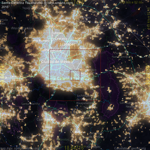
Analysis of Santa Catarina Yecahuizotl night lights 2016
Square area 10x10 km:
 48.05%
90-99
32.9%80-89
17.53%70-79
1.52%60-69
0%50-59
0%40-49
0%30-39
0%20-29
0%10-19
0%0-9
0%Square area 50x50 km:
30.31%90-99
10.56%80-89
9.58%70-79
8.54%60-69
5.76%50-59
3.02%40-49
3.57%30-39
2.6%20-29
5.23%10-19
7.81%0-9
13.03%Clear (daylight) street map image can be seen on geolist.org.
Map coordinates:
19° 58' 27.3" North, 99° 40' 3.9" West
19° 18' 43.4" North, 98° 57' 52.6" West
18° 38' 49.8" North, 98° 15' 41.4" West
Some cities around Santa Catarina Yecahuizotl sort by population:
• Xico
4.9 km =3 mi,  162°
162°
• Tláhuac
5.1 km =3.2 mi,  236°
236°
• Los Reyes Acaquilpan
5.9 km =3.7 mi,  347°
347°
• San Isidro
3.4 km =2.1 mi,  25°
25°
• Emiliano Zapata
3.7 km =2.3 mi,  343°
343°
• El Pino
4.7 km =2.9 mi,  21°
21°
• Tecamachalco
5.3 km =3.3 mi,  5°
5°
• Lomas de Altavista
5.9 km =3.7 mi, 20°
3517649 (p: 9,563)
Sources (retrieved 2019-11-25):
» Earth at Night: Flat Maps 2012, 2016