Tecamachalco night lights from space
Night Light of Tecamachalco (México) from space (Mexico) Src. Average luminocity for 10x10km area is 97.9545% and for 50x50km: 72.3801%.
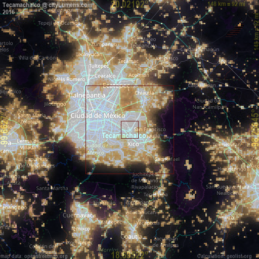
Analysis of Tecamachalco night lights 2016
Square area 10x10 km:
 60.95%
90-99
31.61%80-89
6.82%70-79
0.62%60-69
0%50-59
0%40-49
0%30-39
0%20-29
0%10-19
0%0-9
0%Square area 50x50 km:
32.45%90-99
12.14%80-89
11.8%70-79
10.12%60-69
6.31%50-59
3.08%40-49
3.43%30-39
2.65%20-29
4.88%10-19
6.69%0-9
6.45%Clear (daylight) street map image can be seen on geolist.org.
Map coordinates:
20° 1' 18.9" North, 99° 39' 45.7" West
19° 21' 35.7" North, 98° 57' 34.5" West
18° 41' 42.8" North, 98° 15' 23.2" West
Some cities around Tecamachalco sort by population:
• Los Reyes Acaquilpan
1.9 km =1.2 mi,  282°
282°
• San Isidro
2.4 km =1.5 mi,  157°
157°
• Magdalena Atlicpac
1.5 km =0.9 mi,  46°
46°
• Emiliano Zapata
2.4 km =1.5 mi,  221°
221°
• San Sebastián Chimalpa
2.4 km =1.5 mi,  11°
11°
• Profesor Carlos Hank González
2.6 km =1.6 mi,  57°
57°
• El Pino
1.5 km =0.9 mi,  128°
128°
• Lomas de Altavista
1.6 km =1 mi,  84°
84°
3817670 (p: 6,780)
Sources (retrieved 2019-11-25):
» Earth at Night: Flat Maps 2012, 2016