Santa Ana Tlacotenco night lights from space
Night Light of Santa Ana Tlacotenco (Mexico City) from space (Mexico) Src. Average luminocity for 10x10km area is 50.6753% and for 50x50km: 51.006%.
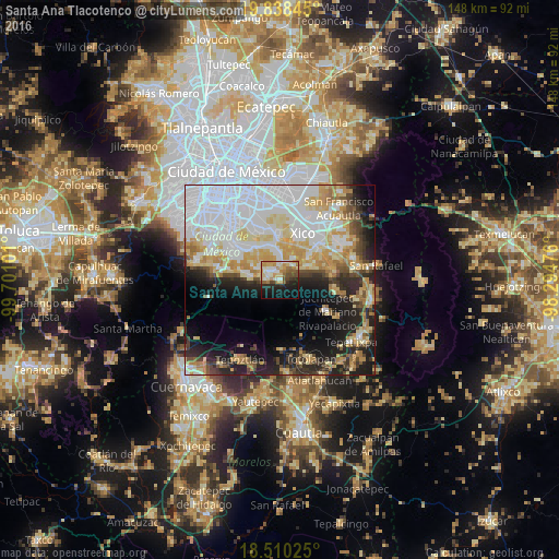
Analysis of Santa Ana Tlacotenco night lights 2016
Square area 10x10 km:
 6.93%
6.93%90-99
9.52%80-89
12.55%70-79
8.66%60-69
6.49%50-59
6.28%40-49
6.28%30-39
2.6%20-29
11.9%10-19
20.13%0-9
8.66%Square area 50x50 km:
19.3%90-99
8.18%80-89
8.02%70-79
6.88%60-69
4.64%50-59
2.54%40-49
4.27%30-39
3.66%20-29
8.09%10-19
12.02%0-9
22.4%Clear (daylight) street map image can be seen on geolist.org.
Map coordinates:
19° 50' 18.4" North, 99° 42' 3.6" West
19° 10' 32.5" North, 98° 59' 52.4" West
18° 30' 36.9" North, 98° 17' 41.1" West
Some cities around Santa Ana Tlacotenco sort by population:
• San Antonio Tecómitl
4.8 km =3 mi,  12°
12°
• San Juan Ixtayopan
6.2 km =3.9 mi,  359°
359°
• Milpa Alta
3.2 km =2 mi,  305°
305°
• San Pablo Oztotepec
8 km =5 mi,  278°
278°
• San Andrés Mixquic
6.5 km =4 mi,  32°
32°
• San Juan y San Pedro Tezompa
5.2 km =3.2 mi,  48°
48°
• San Francisco Tecoxpa
2 km =1.2 mi,  333°
333°
• San Pedro Atocpan
6.2 km =3.9 mi,  297°
297°
3517728 (p: 10,593)
Sources (retrieved 2019-11-25):
» Earth at Night: Flat Maps 2012, 2016