San Pedro Atocpan night lights from space
Night Light of San Pedro Atocpan (Mexico City) from space (Mexico) Src. Average luminocity for 10x10km area is 72.5952% and for 50x50km: 53.854%.
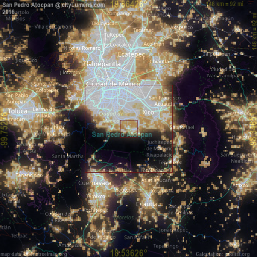
Analysis of San Pedro Atocpan night lights 2016
Square area 10x10 km:
 8.23%
8.23%90-99
14.94%80-89
23.59%70-79
24.89%60-69
6.71%50-59
2.38%40-49
3.68%30-39
3.68%20-29
11.04%10-19
0.87%0-9
0%Square area 50x50 km:
25%90-99
9.09%80-89
7.3%70-79
6.18%60-69
3.85%50-59
2.04%40-49
3.24%30-39
2.49%20-29
4.9%10-19
10.27%0-9
25.63%Clear (daylight) street map image can be seen on geolist.org.
Map coordinates:
19° 51' 51.3" North, 99° 45' 9.9" West
19° 12' 5.8" North, 99° 2' 58.7" West
18° 32' 10.5" North, 98° 20' 47.4" West
Some cities around San Pedro Atocpan sort by population:
• Xochimilco
8.2 km =5.1 mi,  316°
316°
• San Antonio Tecómitl
6.7 km =4.2 mi,  74°
74°
• San Juan Ixtayopan
6.3 km =3.9 mi,  57°
57°
• Milpa Alta
3 km =1.9 mi,  109°
109°
• San Salvador Cuauhtenco
4.3 km =2.7 mi,  256°
256°
• San Andrés Mixquic
9.4 km =5.8 mi, 73°
• San Francisco Tecoxpa
4.7 km =2.9 mi,  103°
103°
• Santa Ana Tlacotenco
6.2 km =3.9 mi,  117°
117°
3827380 (p: 8,283)
Sources (retrieved 2019-11-25):
» Earth at Night: Flat Maps 2012, 2016