San Juan y San Pedro Tezompa night lights from space
Night Light of San Juan y San Pedro Tezompa (México) from space (Mexico) Src. Average luminocity for 10x10km area is 69.3485% and for 50x50km: 50.8114%.
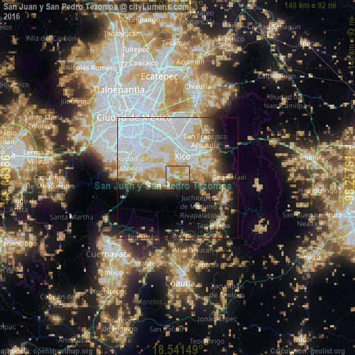
Analysis of San Juan y San Pedro Tezompa night lights 2016
Square area 10x10 km:
 10.82%
90-99
11.9%80-89
16.23%70-79
23.81%60-69
6.93%50-59
4.98%40-49
9.09%30-39
5.63%20-29
8.01%10-19
2.6%0-9
0%Square area 50x50 km:
21.08%90-99
8.51%80-89
7.41%70-79
6.31%60-69
4.06%50-59
2.31%40-49
3.72%30-39
2.67%20-29
6.45%10-19
12.35%0-9
25.12%Clear (daylight) street map image can be seen on geolist.org.
Map coordinates:
19° 52' 9.9" North, 99° 39' 49.9" West
19° 12' 24.5" North, 98° 57' 38.6" West
18° 32' 29.4" North, 98° 15' 27.4" West
Some cities around San Juan y San Pedro Tezompa sort by population:
• San Antonio Tecómitl
3.1 km =1.9 mi,  293°
293°
• Milpa Alta
6.7 km =4.2 mi,  256°
256°
• San Mateo Huitzilzingo
4.5 km =2.8 mi,  56°
56°
• San Andrés Mixquic
2.1 km =1.3 mi,  350°
350°
• San Francisco Tecoxpa
5.1 km =3.2 mi,  250°
250°
• San Pablo Atlazalpan
5.7 km =3.5 mi,  78°
78°
• Santa Catarina Ayotzingo
3.3 km =2.1 mi, 84°
• Santa Ana Tlacotenco
5.2 km =3.2 mi,  228°
228°
3517956 (p: 11,819)
Sources (retrieved 2019-11-25):
» Earth at Night: Flat Maps 2012, 2016