San Andrés Mixquic night lights from space
Night Light of San Andrés Mixquic (Mexico City) from space (Mexico) Src. Average luminocity for 10x10km area is 78.3853% and for 50x50km: 52.7225%.
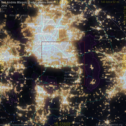
Analysis of San Andrés Mixquic night lights 2016
Square area 10x10 km:
 12.99%
90-99
12.77%80-89
22.73%70-79
30.52%60-69
7.14%50-59
4.11%40-49
6.93%30-39
2.81%20-29
0%10-19
0%0-9
0%Square area 50x50 km:
22.86%90-99
9%80-89
7.75%70-79
6.17%60-69
3.9%50-59
2.2%40-49
3.61%30-39
2.47%20-29
6.21%10-19
11.27%0-9
24.56%Clear (daylight) street map image can be seen on geolist.org.
Map coordinates:
19° 53' 15.6" North, 99° 40' 2" West
19° 13' 30.4" North, 98° 57' 50.7" West
18° 33' 35.6" North, 98° 15' 39.5" West
Some cities around San Andrés Mixquic sort by population:
• Xico
5.2 km =3.2 mi,  15°
15°
• San Juan Ixtayopan
3.7 km =2.3 mi,  281°
281°
• San Mateo Huitzilzingo
4.1 km =2.5 mi,  83°
83°
• San Juan y San Pedro Tezompa
2.1 km =1.3 mi,  170°
170°
• San Francisco Tecoxpa
5.8 km =3.6 mi,  230°
230°
• San Pablo Atlazalpan
6 km =3.7 mi,  98°
98°
• Santa Catarina Ayotzingo
4 km =2.5 mi,  115°
115°
• Santa Ana Tlacotenco
6.5 km =4 mi,  212°
212°
3523124 (p: 13,310)
Sources (retrieved 2019-11-25):
» Earth at Night: Flat Maps 2012, 2016