San Sebastián Chimalpa night lights from space
Night Light of San Sebastián Chimalpa (México) from space (Mexico) Src. Average luminocity for 10x10km area is 98.25% and for 50x50km: 74.013%.
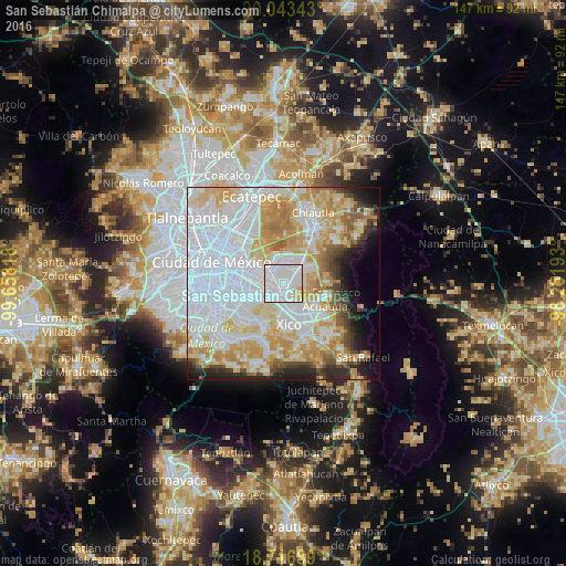
Analysis of San Sebastián Chimalpa night lights 2016
Square area 10x10 km:
 61.16%
90-99
32.85%80-89
4.96%70-79
1.03%60-69
0%50-59
0%40-49
0%30-39
0%20-29
0%10-19
0%0-9
0%Square area 50x50 km:
32.88%90-99
12.83%80-89
12.49%70-79
10.52%60-69
6.25%50-59
3.03%40-49
3.46%30-39
2.72%20-29
4.68%10-19
5%0-9
6.13%Clear (daylight) street map image can be seen on geolist.org.
Map coordinates:
20° 2' 36.3" North, 99° 39' 29.4" West
19° 22' 53.4" North, 98° 57' 18.2" West
18° 43' 0.8" North, 98° 15' 6.9" West
Some cities around San Sebastián Chimalpa sort by population:
• Los Reyes Acaquilpan
3.1 km =1.9 mi,  229°
229°
• Magdalena Atlicpac
1.5 km =0.9 mi,  156°
156°
• Lomas de San Sebastián
2.3 km =1.4 mi,  88°
88°
• Profesor Carlos Hank González
2 km =1.2 mi,  121°
121°
• San José las Palmas
2.7 km =1.7 mi,  125°
125°
• Tecamachalco
2.4 km =1.5 mi,  191°
191°
• Arenal
1.3 km =0.8 mi, 91°
• Lomas de Altavista
2.5 km =1.6 mi,  154°
154°
3817672 (p: 12,951)
Sources (retrieved 2019-11-25):
» Earth at Night: Flat Maps 2012, 2016