Arenal night lights from space
Night Light of Arenal (México) from space (Mexico) Src. Average luminocity for 10x10km area is 97.2624% and for 50x50km: 71.7991%.
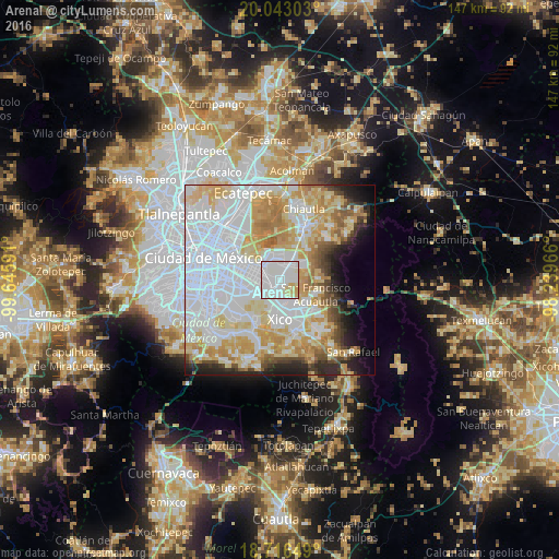
Analysis of Arenal night lights 2016
Square area 10x10 km:
 55.17%
90-99
33.47%80-89
9.09%70-79
2.27%60-69
0%50-59
0%40-49
0%30-39
0%20-29
0%10-19
0%0-9
0%Square area 50x50 km:
31.13%90-99
12.55%80-89
12.29%70-79
10.49%60-69
6.19%50-59
3.06%40-49
3.41%30-39
2.73%20-29
4.61%10-19
5.07%0-9
8.47%Clear (daylight) street map image can be seen on geolist.org.
Map coordinates:
20° 2' 34.9" North, 99° 38' 45.3" West
19° 22' 52" North, 98° 56' 34" West
18° 42' 59.4" North, 98° 14' 22.8" West
Some cities around Arenal sort by population:
• Magdalena Atlicpac
1.5 km =0.9 mi,  207°
207°
• San Sebastián Chimalpa
1.3 km =0.8 mi,  271°
271°
• Lomas de San Sebastián
1 km =0.6 mi,  83°
83°
• Profesor Carlos Hank González
1.1 km =0.7 mi,  157°
157°
• El Pino
3.4 km =2.1 mi,  189°
189°
• San José las Palmas
1.8 km =1.1 mi,  148°
148°
• Tecamachalco
2.9 km =1.8 mi,  216°
216°
• Lomas de Altavista
2.2 km =1.4 mi, 185°
8858209 (p: 6,700)
Sources (retrieved 2019-11-25):
» Earth at Night: Flat Maps 2012, 2016