San Nicolás de los Ranchos night lights from space
Night Light of San Nicolás de los Ranchos (Puebla) from space (Mexico) Src. Average luminocity for 10x10km area is 19.1017% and for 50x50km: 34.5432%.
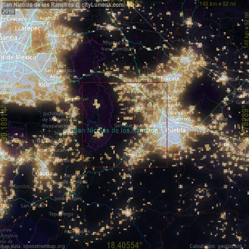
Analysis of San Nicolás de los Ranchos night lights 2016
Square area 10x10 km:
 0%
0%90-99
0.22%80-89
7.14%70-79
3.9%60-69
4.33%50-59
0%40-49
1.52%30-39
1.08%20-29
0.87%10-19
25.32%0-9
55.63%Square area 50x50 km:
3.47%90-99
3.44%80-89
9.24%70-79
6.8%60-69
6.67%50-59
5.78%40-49
5.68%30-39
3.85%20-29
4.77%10-19
8.01%0-9
42.29%Clear (daylight) street map image can be seen on geolist.org.
Map coordinates:
19° 44' 4.5" North, 99° 11' 20.9" West
19° 4' 17" North, 98° 29' 9.6" West
18° 24' 19.9" North, 97° 46' 58.4" West
Some cities around San Nicolás de los Ranchos sort by population:
• Huejotzingo
12.7 km =7.9 mi,  40°
40°
• Santa María Zacatepec
13.9 km =8.6 mi,  65°
65°
• Nealtican
6.6 km =4.1 mi,  111°
111°
• San Lorenzo Chiautzingo
14.9 km =9.3 mi,  7°
7°
• San Andrés Calpan
4.4 km =2.7 mi, 35°
• Zacapechpan
14.3 km =8.9 mi,  97°
97°
• Domingo Arenas
8.2 km =5.1 mi,  21°
21°
• Tianguismanalco
11.3 km =7 mi,  159°
159°
3518181 (p: 5,685)
Sources (retrieved 2019-11-25):
» Earth at Night: Flat Maps 2012, 2016