San Miguel Vindho night lights from space
Night Light of San Miguel Vindho (Hidalgo) from space (Mexico) Src. Average luminocity for 10x10km area is 60.7222% and for 50x50km: 31.0483%.
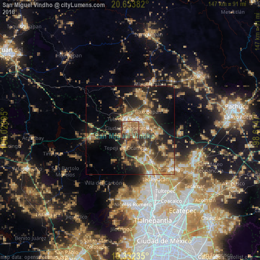
Analysis of San Miguel Vindho night lights 2016
Square area 10x10 km:
 2.38%
2.38%90-99
3.57%80-89
5.16%70-79
18.65%60-69
25.4%50-59
16.27%40-49
17.86%30-39
7.34%20-29
3.37%10-19
0%0-9
0%Square area 50x50 km:
1.62%90-99
2.36%80-89
4.32%70-79
6.17%60-69
9.31%50-59
5.1%40-49
6.3%30-39
6.56%20-29
9.22%10-19
13.08%0-9
35.95%Clear (daylight) street map image can be seen on geolist.org.
Map coordinates:
20° 39' 13.8" North, 100° 1' 15.4" West
19° 59' 40.1" North, 99° 19' 4.2" West
19° 19' 56.5" North, 98° 36' 52.9" West
Some cities around San Miguel Vindho sort by population:
• Tepeji del Río de Ocampo
10.3 km =6.4 mi,  195°
195°
• Tula de Allende
6.9 km =4.3 mi,  336°
336°
• El Llano
7.9 km =4.9 mi,  358°
358°
• Tlaxcoapan
14.8 km =9.2 mi,  43°
43°
• Cardonal
11.5 km =7.1 mi,  52°
52°
• Atotonilco de Tula
10.5 km =6.5 mi,  81°
81°
• Doxey
13.3 km =8.3 mi, 35°
• Atitalaquia
12.4 km =7.7 mi, 54°
3827537 (p: 7,988)
Sources (retrieved 2019-11-25):
» Earth at Night: Flat Maps 2012, 2016