San Mateo Huitzilzingo night lights from space
Night Light of San Mateo Huitzilzingo (México) from space (Mexico) Src. Average luminocity for 10x10km area is 78.3896% and for 50x50km: 48.8145%.
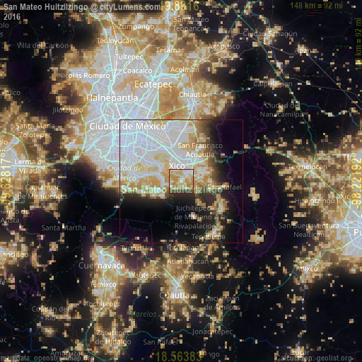
Analysis of San Mateo Huitzilzingo night lights 2016
Square area 10x10 km:
 12.55%
90-99
15.8%80-89
22.29%70-79
25.76%60-69
8.87%50-59
2.6%40-49
9.09%30-39
2.81%20-29
0.22%10-19
0%0-9
0%Square area 50x50 km:
19.89%90-99
8.68%80-89
7.43%70-79
6.14%60-69
3.75%50-59
2.18%40-49
3.48%30-39
2.37%20-29
5.89%10-19
10.22%0-9
29.96%Clear (daylight) street map image can be seen on geolist.org.
Map coordinates:
19° 53' 29.8" North, 99° 37' 41.4" West
19° 13' 44.6" North, 98° 55' 30.1" West
18° 33' 49.8" North, 98° 13' 18.9" West
Some cities around San Mateo Huitzilzingo sort by population:
• Xico
5.3 km =3.3 mi,  329°
329°
• Chalco
4.6 km =2.9 mi,  38°
38°
• San Andrés Mixquic
4.1 km =2.5 mi,  263°
263°
• San Juan y San Pedro Tezompa
4.5 km =2.8 mi,  236°
236°
• San Pablo Atlazalpan
2.2 km =1.4 mi,  125°
125°
• Santa Catarina Ayotzingo
2.2 km =1.4 mi,  193°
193°
• Cocotitlán
6.2 km =3.9 mi,  85°
85°
• Temamatla
6.5 km =4 mi,  116°
116°
3817641 (p: 15,389)
Sources (retrieved 2019-11-25):
» Earth at Night: Flat Maps 2012, 2016