San Marcos de León night lights from space
Night Light of San Marcos de León (Veracruz) from space (Mexico) Src. Average luminocity for 10x10km area is 30.8058% and for 50x50km: 10.2182%.
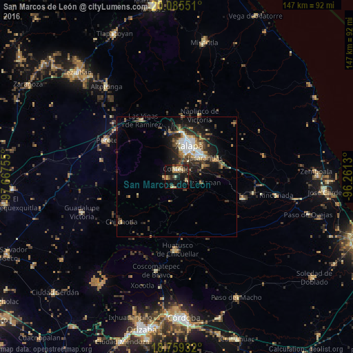
Analysis of San Marcos de León night lights 2016
Square area 10x10 km:
 1.24%
1.24%90-99
1.86%80-89
8.06%70-79
3.51%60-69
7.85%50-59
2.27%40-49
5.17%30-39
5.37%20-29
9.92%10-19
30.17%0-9
24.59%Square area 50x50 km:
1.38%90-99
1.24%80-89
1.14%70-79
1.13%60-69
1.49%50-59
1.23%40-49
1.95%30-39
2.44%20-29
3.33%10-19
6.34%0-9
78.32%Clear (daylight) street map image can be seen on geolist.org.
Map coordinates:
20° 5' 7.8" North, 97° 40' 3.2" West
19° 25' 25.6" North, 96° 57' 51.9" West
18° 45' 33.6" North, 96° 15' 40.7" West
Some cities around San Marcos de León sort by population:
• Xalapa de Enríquez
13 km =8.1 mi,  23°
23°
• Coatepec
3.2 km =2 mi,  5°
5°
• Xico
4.6 km =2.9 mi,  267°
267°
• Teocelo
4.4 km =2.7 mi,  192°
192°
• Colonia Santa Bárbara
12.5 km =7.8 mi,  46°
46°
• Jacarandas
14.2 km =8.8 mi,  55°
55°
• Tuzamapan
10.8 km =6.7 mi,  102°
102°
• Lomas Verdes
12 km =7.5 mi,  41°
41°
3518456 (p: 7,256)
Sources (retrieved 2019-11-25):
» Earth at Night: Flat Maps 2012, 2016