Jacarandas night lights from space
Night Light of Jacarandas (Veracruz) from space (Mexico) Src. Average luminocity for 10x10km area is 47.1529% and for 50x50km: 10.5612%.
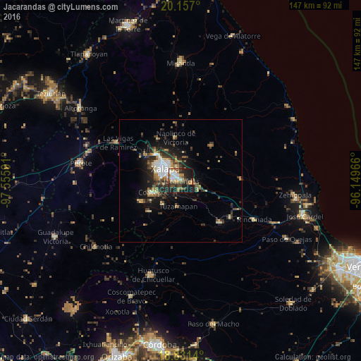
Analysis of Jacarandas night lights 2016
Square area 10x10 km:
 6.4%
6.4%90-99
10.54%80-89
4.75%70-79
7.64%60-69
7.02%50-59
3.93%40-49
9.71%30-39
8.26%20-29
16.12%10-19
24.17%0-9
1.45%Square area 50x50 km:
1.4%90-99
1.36%80-89
1.16%70-79
1.25%60-69
1.44%50-59
1.19%40-49
2.12%30-39
2.4%20-29
3.48%10-19
6.29%0-9
77.91%Clear (daylight) street map image can be seen on geolist.org.
Map coordinates:
20° 9' 25.2" North, 97° 33' 21.3" West
19° 29' 44" North, 96° 51' 10" West
18° 49' 53" North, 96° 8' 58.8" West
Some cities around Jacarandas sort by population:
• Xalapa de Enríquez
7.7 km =4.8 mi,  300°
300°
• Coatepec
12.4 km =7.7 mi,  247°
247°
• Banderilla
13.6 km =8.5 mi,  319°
319°
• Colonia Santa Bárbara
2.8 km =1.7 mi,  284°
284°
• Tuzamapan
10.4 km =6.5 mi,  186°
186°
• Lomas Verdes
3.9 km =2.4 mi, 284°
• Guadalupe Victoria
13.1 km =8.1 mi, 300°
• El Castillo
5.8 km =3.6 mi,  348°
348°
8858181 (p: 8,351)
Sources (retrieved 2019-11-25):
» Earth at Night: Flat Maps 2012, 2016