Xico night lights from space
Night Light of Xico (Veracruz) from space (Mexico) Src. Average luminocity for 10x10km area is 18.1322% and for 50x50km: 10.6336%.
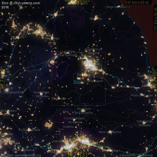
Analysis of Xico night lights 2016
Square area 10x10 km:
 0.62%
0.62%90-99
1.03%80-89
5.99%70-79
3.1%60-69
2.07%50-59
0.83%40-49
2.89%30-39
3.31%20-29
4.13%10-19
15.08%0-9
60.95%Square area 50x50 km:
1.42%90-99
1.27%80-89
1.18%70-79
1.18%60-69
1.58%50-59
1.34%40-49
2.04%30-39
2.48%20-29
3.43%10-19
6.64%0-9
77.44%Clear (daylight) street map image can be seen on geolist.org.
Map coordinates:
20° 5' 0.7" North, 97° 42' 40.8" West
19° 25' 18.4" North, 97° 0' 29.5" West
18° 45' 26.4" North, 96° 18' 18.3" West
Some cities around Xico sort by population:
• Xalapa de Enríquez
15.5 km =9.6 mi,  38°
38°
• Coatepec
6 km =3.7 mi,  55°
55°
• Teocelo
5.4 km =3.4 mi,  138°
138°
• Colonia Santa Bárbara
16.3 km =10.1 mi, 56°
• Tuzamapan
15.3 km =9.5 mi,  98°
98°
• San Marcos de León
4.6 km =2.9 mi,  87°
87°
• Lomas Verdes
15.5 km =9.6 mi,  53°
53°
• Guadalupe Victoria
15.6 km =9.7 mi,  18°
18°
3514518 (p: 18,652)
Sources (retrieved 2019-11-25):
» Earth at Night: Flat Maps 2012, 2016