Ojocaliente night lights from space
Night Light of Ojocaliente (Aguascalientes) from space (Mexico) Src. Average luminocity for 10x10km area is 22.7619% and for 50x50km: 3.3949%.
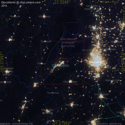
Analysis of Ojocaliente night lights 2016
Square area 10x10 km:
 0.6%
0.6%90-99
1.79%80-89
6.94%70-79
3.37%60-69
3.97%50-59
3.57%40-49
1.98%30-39
3.57%20-29
2.38%10-19
17.46%0-9
54.37%Square area 50x50 km:
0.02%90-99
0.31%80-89
0.76%70-79
0.53%60-69
0.41%50-59
0.56%40-49
0.62%30-39
0.6%20-29
0.48%10-19
1.72%0-9
94%Clear (daylight) street map image can be seen on geolist.org.
Map coordinates:
22° 31' 29.6" North, 103° 22' 47.9" West
21° 52' 26" North, 102° 40' 36.6" West
21° 13' 11.7" North, 101° 58' 25.4" West
Some cities around Ojocaliente sort by population:
• Aguascalientes
40.7 km =25.3 mi,  88°
88°
• Jesús María
35.7 km =22.2 mi,  74°
74°
• Calvillo
5.3 km =3.3 mi,  234°
234°
• Villa Hidalgo
23.8 km =14.8 mi,  157°
157°
• Jalpa
41 km =25.5 mi, 229°
• Jesús Gómez Portugal (Margaritas)
42.1 km =26.2 mi, 70°
• Tabasco
24.2 km =15 mi,  267°
267°
• Pocitos
35.7 km =22.2 mi,  81°
81°
4021095 (p: 6,914)
Sources (retrieved 2019-11-25):
» Earth at Night: Flat Maps 2012, 2016