Jesús Gómez Portugal (Margaritas) night lights from space
Night Light of Jesús Gómez Portugal (Margaritas) (Aguascalientes) from space (Mexico) Src. Average luminocity for 10x10km area is 69.1984% and for 50x50km: 23.5892%.
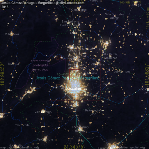
Analysis of Jesús Gómez Portugal (Margaritas) night lights 2016
Square area 10x10 km:
 7.54%
7.54%90-99
13.89%80-89
12.7%70-79
22.02%60-69
12.5%50-59
10.52%40-49
11.71%30-39
2.78%20-29
5.75%10-19
0.6%0-9
0%Square area 50x50 km:
3.83%90-99
3.49%80-89
3.62%70-79
3.85%60-69
2.41%50-59
2.81%40-49
4.38%30-39
3.33%20-29
5.99%10-19
10.79%0-9
55.51%Clear (daylight) street map image can be seen on geolist.org.
Map coordinates:
22° 38' 58.5" North, 102° 59' 40.3" West
21° 59' 57" North, 102° 17' 29" West
21° 20' 44.7" North, 101° 35' 17.8" West
Some cities around Jesús Gómez Portugal (Margaritas) sort by population:
• Aguascalientes
13 km =8.1 mi,  176°
176°
• Pabellón de Arteaga
16.4 km =10.2 mi,  5°
5°
• Rincón de Romos
25.7 km =16 mi,  352°
352°
• San Francisco de los Romo
8.9 km =5.5 mi, 13°
• Ojocaliente
42.1 km =26.2 mi,  250°
250°
• Villa García
39 km =24.2 mi,  62°
62°
• Palo Alto
34.9 km =21.7 mi,  104°
104°
• Pocitos
9.7 km =6 mi,  207°
207°
4021296 (p: 11,589)
Sources (retrieved 2019-11-25):
» Earth at Night: Flat Maps 2012, 2016