Villa Hidalgo night lights from space
Night Light of Villa Hidalgo (Jalisco) from space (Mexico) Src. Average luminocity for 10x10km area is 11.2102% and for 50x50km: 5.2887%.
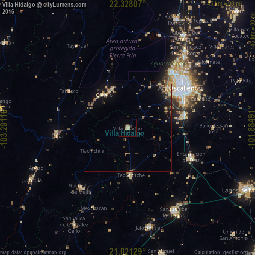
Analysis of Villa Hidalgo night lights 2016
Square area 10x10 km:
 0%
0%90-99
3.22%80-89
2.84%70-79
0.57%60-69
0.95%50-59
1.7%40-49
1.33%30-39
0.76%20-29
0.76%10-19
1.14%0-9
86.74%Square area 50x50 km:
0.04%90-99
0.41%80-89
1.28%70-79
0.67%60-69
0.77%50-59
0.73%40-49
1.17%30-39
0.9%20-29
1.13%10-19
3.28%0-9
89.62%Clear (daylight) street map image can be seen on geolist.org.
Map coordinates:
22° 19' 41.1" North, 103° 17' 28.2" West
21° 40' 34.2" North, 102° 35' 16.9" West
21° 1' 16.6" North, 101° 53' 5.7" West
Some cities around Villa Hidalgo sort by population:
• Aguascalientes
39 km =24.2 mi,  53°
53°
• Jesús María
40.5 km =25.2 mi,  38°
38°
• Encarnación de Díaz
39.6 km =24.6 mi,  114°
114°
• Teocaltiche
26.9 km =16.7 mi,  177°
177°
• Calvillo
23.2 km =14.4 mi,  324°
324°
• Tabasco
39.3 km =24.4 mi,  301°
301°
• Ojocaliente
23.8 km =14.8 mi,  337°
337°
• Pocitos
37.8 km =23.5 mi, 43°
3980169 (p: 15,182)
Sources (retrieved 2019-11-25):
» Earth at Night: Flat Maps 2012, 2016