Ocampo night lights from space
Night Light of Ocampo (Guanajuato) from space (Mexico) Src. Average luminocity for 10x10km area is 6.8144% and for 50x50km: 1.3928%.
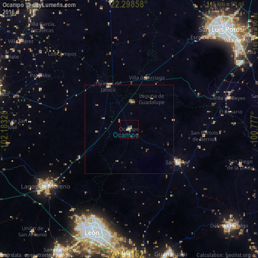
Analysis of Ocampo night lights 2016
Square area 10x10 km:
 0%
0%90-99
0.38%80-89
1.52%70-79
2.27%60-69
1.14%50-59
0%40-49
1.52%30-39
2.08%20-29
0.95%10-19
0%0-9
90.15%Square area 50x50 km:
0.05%90-99
0.1%80-89
0.28%70-79
0.28%60-69
0.13%50-59
0.2%40-49
0.34%30-39
0.23%20-29
0.33%10-19
0.24%0-9
97.83%Clear (daylight) street map image can be seen on geolist.org.
Map coordinates:
22° 17' 54.9" North, 102° 10' 59.7" West
21° 38' 47.5" North, 101° 28' 48.4" West
20° 59' 29.5" North, 100° 46' 37.2" West
Some cities around Ocampo sort by population:
• Lagos de Moreno
57.3 km =35.6 mi,  235°
235°
• San Felipe
33.1 km =20.6 mi,  124°
124°
• Medina
57.2 km =35.5 mi,  194°
194°
• Ojuelos de Jalisco
27 km =16.8 mi,  334°
334°
• Villa de Reyes
59 km =36.7 mi,  72°
72°
• San Bartolo de Berrios
42.7 km =26.5 mi,  95°
95°
• Villa de Arriaga
30.9 km =19.2 mi,  19°
19°
• Palo Alto
58.4 km =36.3 mi,  301°
301°
3994535 (p: 6,499)
Sources (retrieved 2019-11-25):
» Earth at Night: Flat Maps 2012, 2016