Adolfo López Mateos (El Tamarindo) night lights from space
Night Light of Adolfo López Mateos (El Tamarindo) (Sinaloa) from space (Mexico) Src. Average luminocity for 10x10km area is 6.0284% and for 50x50km: 11.8863%.
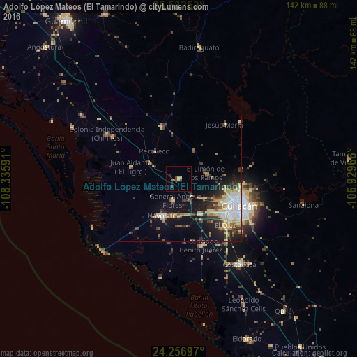
Analysis of Adolfo López Mateos (El Tamarindo) night lights 2016
Square area 10x10 km:
 0%
0%90-99
0%80-89
0.76%70-79
1.7%60-69
0.57%50-59
1.14%40-49
1.14%30-39
1.7%20-29
2.65%10-19
0.19%0-9
90.15%Square area 50x50 km:
2.25%90-99
1.63%80-89
2.03%70-79
1.33%60-69
1.23%50-59
1.21%40-49
1.84%30-39
2.01%20-29
2.63%10-19
6.82%0-9
77.02%Clear (daylight) street map image can be seen on geolist.org.
Map coordinates:
25° 31' 57.1" North, 108° 20' 9.3" West
24° 53' 47" North, 107° 37' 58" West
24° 15' 25.1" North, 106° 55' 46.8" West
Some cities around Adolfo López Mateos (El Tamarindo) sort by population:
• Culiacán
27.4 km =17 mi,  115°
115°
• Navolato
16.1 km =10 mi,  205°
205°
• Villa de Costa Rica
41.9 km =26 mi,  143°
143°
• Licenciado Benito Juárez (Campo Gobierno)
28.1 km =17.5 mi,  161°
161°
• Villa Juárez
28 km =17.4 mi, 160°
• General Ángel Flores (La Palma)
8.9 km =5.5 mi,  195°
195°
• El Diez
26.5 km =16.5 mi, 136°
• Pericos
21.6 km =13.4 mi,  341°
341°
8858251 (p: 5,546)
Sources (retrieved 2019-11-25):
» Earth at Night: Flat Maps 2012, 2016