Jilotepec de Molina Enríquez night lights from space
Night Light of Jilotepec de Molina Enríquez (México) from space (Mexico) Src. Average luminocity for 10x10km area is 33.881% and for 50x50km: 13.0381%.
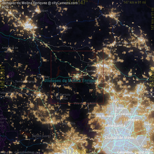
Analysis of Jilotepec de Molina Enríquez night lights 2016
Square area 10x10 km:
 0.65%
0.65%90-99
1.08%80-89
1.73%70-79
8.23%60-69
8.87%50-59
6.93%40-49
11.26%30-39
9.74%20-29
4.11%10-19
33.55%0-9
13.85%Square area 50x50 km:
0.3%90-99
0.4%80-89
1.17%70-79
2.16%60-69
3.6%50-59
2.09%40-49
3.53%30-39
3.23%20-29
3.99%10-19
8.7%0-9
70.82%Clear (daylight) street map image can be seen on geolist.org.
Map coordinates:
20° 36' 41.3" North, 100° 14' 9.3" West
19° 57' 7" North, 99° 31' 58" West
19° 17' 22.7" North, 98° 49' 46.8" West
Some cities around Jilotepec de Molina Enríquez sort by population:
• Tepeji del Río de Ocampo
20.4 km =12.7 mi,  104°
104°
• Tula de Allende
22.6 km =14 mi,  60°
60°
• El Llano
25.6 km =15.9 mi, 60°
• San Marcos
22.4 km =13.9 mi,  67°
67°
• Villa del Carbón
25.8 km =16 mi,  163°
163°
• San Miguel Vindho
23 km =14.3 mi,  78°
78°
• Santiago Acutzilapan
30.5 km =19 mi,  232°
232°
• Santa Gertrudis
29.9 km =18.6 mi,  144°
144°
3526501 (p: 11,828)
Sources (retrieved 2019-11-25):
» Earth at Night: Flat Maps 2012, 2016