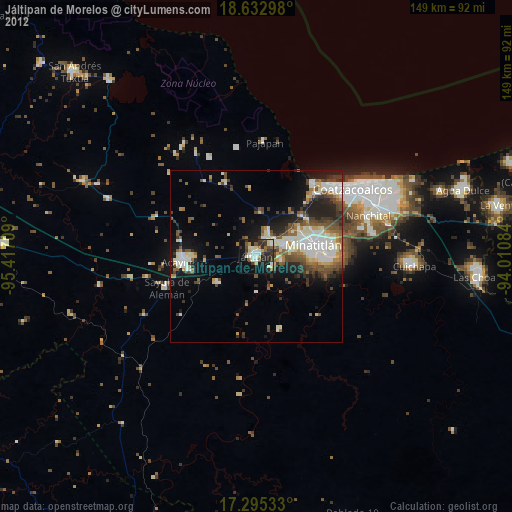
Jáltipan de Morelos night lights from space
Night Light of Jáltipan de Morelos (Veracruz) from space (Mexico) Src. Average luminocity for 10x10km area is 36.158% and for 50x50km: 17.387%.
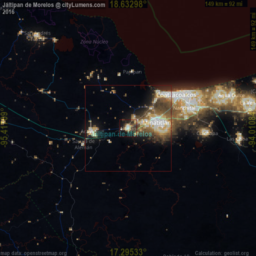
Analysis of Jáltipan de Morelos night lights 2016
Square area 10x10 km:
 1.52%
1.52%90-99
3.9%80-89
8.44%70-79
5.41%60-69
3.03%50-59
3.25%40-49
8.23%30-39
12.99%20-29
13.64%10-19
25.54%0-9
14.07%Square area 50x50 km:
1.67%90-99
3.25%80-89
2.88%70-79
2.12%60-69
1.89%50-59
2.95%40-49
4.61%30-39
3.75%20-29
2.93%10-19
7.03%0-9
66.91%Clear (daylight) street map image can be seen on geolist.org.
Map coordinates:
18° 37' 58.7" North, 95° 25' 1.5" West
17° 57' 55.5" North, 94° 42' 50.3" West
17° 17' 43.2" North, 94° 0' 39" West
Some cities around Jáltipan de Morelos sort by population:
• Minatitlán
17.1 km =10.6 mi,  76°
76°
• Cosoleacaque
9.1 km =5.7 mi,  65°
65°
• Oteapan
6.5 km =4 mi,  51°
51°
• Texistepec
13.4 km =8.3 mi,  234°
234°
• Zaragoza
7.6 km =4.7 mi,  96°
96°
• El Naranjito
11.9 km =7.4 mi, 72°
• Chinameca
7.3 km =4.5 mi,  30°
30°
• Coacotla
5.9 km =3.7 mi,  122°
122°
3526593 (p: 32,778)
Sources (retrieved 2019-11-25):
» Earth at Night: Flat Maps 2012, 2016