Coacotla night lights from space
Night Light of Coacotla (Veracruz) from space (Mexico) Src. Average luminocity for 10x10km area is 33.0281% and for 50x50km: 19.0364%.
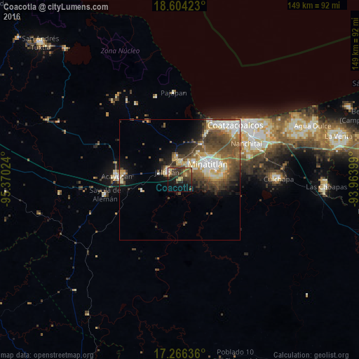
Analysis of Coacotla night lights 2016
Square area 10x10 km:
 0.43%
0.43%90-99
1.3%80-89
5.19%70-79
6.49%60-69
3.46%50-59
8.23%40-49
8.44%30-39
14.72%20-29
9.96%10-19
19.7%0-9
22.08%Square area 50x50 km:
2.11%90-99
3.54%80-89
2.8%70-79
2.19%60-69
2.47%50-59
3.9%40-49
5.44%30-39
3.94%20-29
2.57%10-19
5.66%0-9
65.39%Clear (daylight) street map image can be seen on geolist.org.
Map coordinates:
18° 36' 15.2" North, 95° 22' 12.9" West
17° 56' 11.6" North, 94° 40' 1.6" West
17° 15' 58.9" North, 93° 57' 50.4" West
Some cities around Coacotla sort by population:
• Minatitlán
13.6 km =8.5 mi,  58°
58°
• Jáltipan de Morelos
5.9 km =3.7 mi,  302°
302°
• Cosoleacaque
7.7 km =4.8 mi,  25°
25°
• Oteapan
7.2 km =4.5 mi,  0°
0°
• Texistepec
16.5 km =10.3 mi,  253°
253°
• Zaragoza
3.5 km =2.2 mi,  47°
47°
• El Naranjito
9.3 km =5.8 mi,  43°
43°
• Chinameca
9.6 km =6 mi,  352°
352°
3530568 (p: 6,873)
Sources (retrieved 2019-11-25):
» Earth at Night: Flat Maps 2012, 2016