Isla Mujeres night lights from space
Night Light of Isla Mujeres (Quintana Roo) from space (Mexico) Src. Average luminocity for 10x10km area is 9.3651% and for 50x50km: 10.6915%.
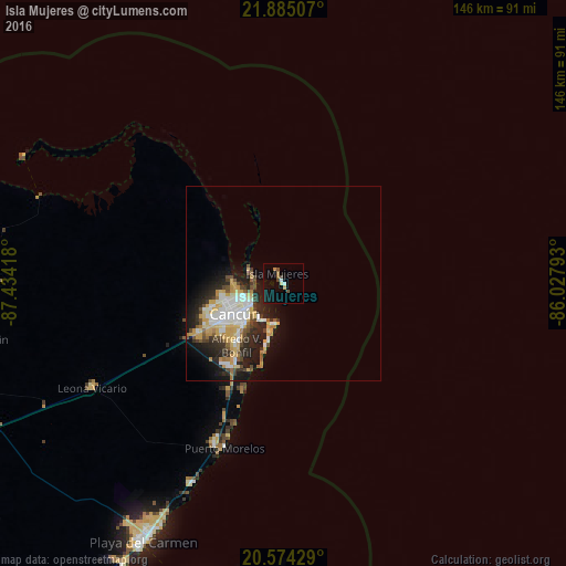
Analysis of Isla Mujeres night lights 2016
Square area 10x10 km:
 1.19%
1.19%90-99
0.4%80-89
0.99%70-79
1.39%60-69
1.59%50-59
0%40-49
2.78%30-39
0.4%20-29
0%10-19
9.52%0-9
81.75%Square area 50x50 km:
1.86%90-99
2.04%80-89
1.59%70-79
1.86%60-69
0.8%50-59
0.81%40-49
1.46%30-39
1.2%20-29
3.66%10-19
5.44%0-9
79.27%Clear (daylight) street map image can be seen on geolist.org.
Map coordinates:
21° 53' 6.3" North, 87° 26' 3" West
21° 13' 52.1" North, 86° 43' 51.8" West
20° 34' 27.4" North, 86° 1' 40.5" West
Some cities around Isla Mujeres sort by population:
• Cancún
13.5 km =8.4 mi,  242°
242°
• Playa del Carmen
76.3 km =47.4 mi,  208°
208°
• Cozumel
84.2 km =52.3 mi,  195°
195°
• Alfredo V. Bonfil
20 km =12.4 mi,  217°
217°
• Kantunilkín
79.6 km =49.5 mi,  259°
259°
• Puerto Aventuras
96.1 km =59.7 mi, 212°
• Leona Vicario
55.8 km =34.7 mi, 241°
• X-Cán
105.9 km =65.8 mi,  246°
246°
3526756 (p: 12,642)
Sources (retrieved 2019-11-25):
» Earth at Night: Flat Maps 2012, 2016