Estación Huehuetán night lights from space
Night Light of Estación Huehuetán (Chiapas) from space (Mexico) Src. Average luminocity for 10x10km area is 6.9793% and for 50x50km: 7.9034%.
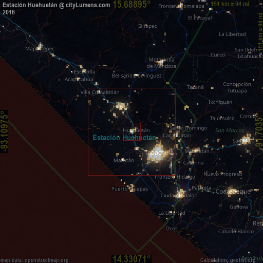
Analysis of Estación Huehuetán night lights 2016
Square area 10x10 km:
 0%
0%90-99
1.65%80-89
0%70-79
1.65%60-69
0.83%50-59
1.86%40-49
1.45%30-39
0.83%20-29
1.65%10-19
0.83%0-9
89.26%Square area 50x50 km:
0.62%90-99
1.26%80-89
1.06%70-79
0.82%60-69
0.98%50-59
0.88%40-49
1.51%30-39
1.65%20-29
2.41%10-19
5.86%0-9
82.95%Clear (daylight) street map image can be seen on geolist.org.
Map coordinates:
15° 41' 20.2" North, 93° 6' 35.1" West
15° 0' 39.3" North, 92° 24' 23.8" West
14° 19' 50.6" North, 91° 42' 12.6" West
Some cities around Estación Huehuetán sort by population:
• Tapachula
20 km =12.4 mi,  126°
126°
• Huixtla
15.5 km =9.6 mi,  336°
336°
• Cacahoatán
26.2 km =16.3 mi,  94°
94°
• Huehuetán
2.8 km =1.7 mi,  69°
69°
• Tuxtla Chico
26.9 km =16.7 mi,  107°
107°
• Mazatán
17.1 km =10.6 mi,  195°
195°
• Vida Mejor I
19 km =11.8 mi,  145°
145°
• Álvaro Obregón
10.3 km =6.4 mi,  162°
162°
9532425 (p: 6,314)
Sources (retrieved 2019-11-25):
» Earth at Night: Flat Maps 2012, 2016