Mazatán night lights from space
Night Light of Mazatán (Chiapas) from space (Mexico) Src. Average luminocity for 10x10km area is 4.2025% and for 50x50km: 5.483%.
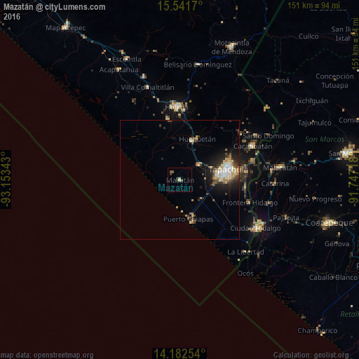
Analysis of Mazatán night lights 2016
Square area 10x10 km:
 0%
0%90-99
0.41%80-89
1.24%70-79
0%60-69
0%50-59
2.27%40-49
0.41%30-39
2.07%20-29
0.21%10-19
0%0-9
93.39%Square area 50x50 km:
0.58%90-99
1.06%80-89
0.7%70-79
0.67%60-69
0.76%50-59
0.45%40-49
0.93%30-39
0.99%20-29
1.43%10-19
3.12%0-9
89.31%Clear (daylight) street map image can be seen on geolist.org.
Map coordinates:
15° 32' 30.1" North, 93° 9' 12.3" West
14° 51' 47.5" North, 92° 27' 1.1" West
14° 10' 57.1" North, 91° 44' 49.8" West
Some cities around Mazatán sort by population:
• Tapachula
21.2 km =13.2 mi,  77°
77°
• Huixtla
30.7 km =19.1 mi,  357°
357°
• Puerto Madero
16.1 km =10 mi,  168°
168°
• Huehuetán
18.9 km =11.7 mi,  22°
22°
• Tuxtla Chico
31.6 km =19.6 mi,  74°
74°
• Vida Mejor I
15.3 km =9.5 mi,  87°
87°
• Estación Huehuetán
17.1 km =10.6 mi, 15°
• Álvaro Obregón
10.2 km =6.3 mi,  49°
49°
3523418 (p: 6,838)
Sources (retrieved 2019-11-25):
» Earth at Night: Flat Maps 2012, 2016