El Cóporo night lights from space
Night Light of El Cóporo (México) from space (Mexico) Src. Average luminocity for 10x10km area is 18.7922% and for 50x50km: 21.0616%.
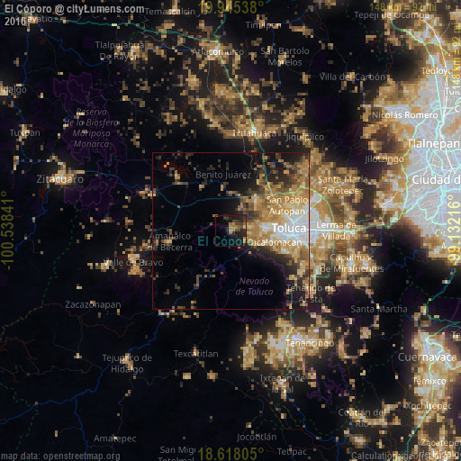
Analysis of El Cóporo night lights 2016
Square area 10x10 km:
 0%
0%90-99
0%80-89
0.87%70-79
0.65%60-69
6.71%50-59
3.46%40-49
4.55%30-39
6.28%20-29
10.82%10-19
20.35%0-9
46.32%Square area 50x50 km:
2.62%90-99
1.94%80-89
3.52%70-79
3.9%60-69
5.21%50-59
2.95%40-49
3.1%30-39
3.21%20-29
5.22%10-19
7.15%0-9
61.19%Clear (daylight) street map image can be seen on geolist.org.
Map coordinates:
19° 56' 43.4" North, 100° 32' 18.3" West
19° 16' 59" North, 99° 50' 7" West
18° 37' 5" North, 99° 7' 55.8" West
Some cities around El Cóporo sort by population:
• Zinacantepec
10.6 km =6.6 mi,  89°
89°
• San Francisco Tlalcilalcalpan
7.2 km =4.5 mi,  79°
79°
• San Antonio Acahualco
6.7 km =4.2 mi,  98°
98°
• San Juan de las Huertas
9 km =5.6 mi,  116°
116°
• Ejido San Lorenzo Cuauhtenco
9.2 km =5.7 mi, 77°
• Santa Cruz Cuauhtenco
11.7 km =7.3 mi,  108°
108°
• Barrio de México
0.7 km =0.4 mi, 94°
• Conjunto Urbano la Loma I
11.9 km =7.4 mi,  66°
66°
8858230 (p: 6,068)
Sources (retrieved 2019-11-25):
» Earth at Night: Flat Maps 2012, 2016