Cuetzalan night lights from space
Night Light of Cuetzalan (Puebla) from space (Mexico) Src. Average luminocity for 10x10km area is 7.5456% and for 50x50km: 7.2393%.
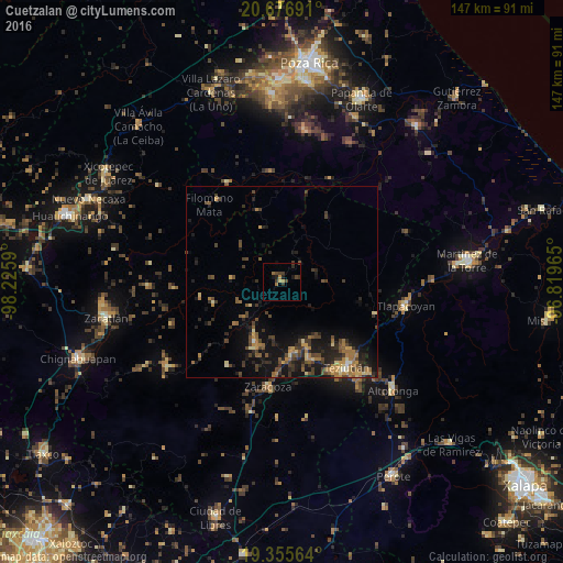
Analysis of Cuetzalan night lights 2016
Square area 10x10 km:
 0%
0%90-99
0%80-89
0.79%70-79
1.19%60-69
1.98%50-59
0%40-49
3.17%30-39
3.97%20-29
1.98%10-19
1.98%0-9
84.92%Square area 50x50 km:
0.08%90-99
0.19%80-89
0.85%70-79
1.05%60-69
1.6%50-59
0.97%40-49
2.32%30-39
1.92%20-29
2.21%10-19
6.44%0-9
82.39%Clear (daylight) street map image can be seen on geolist.org.
Map coordinates:
20° 40' 36.9" North, 98° 13' 33.2" West
20° 1' 3.6" North, 97° 31' 22" West
19° 21' 20.3" North, 96° 49' 10.7" West
Some cities around Cuetzalan sort by population:
• Tlatlauquitepec
19.1 km =11.9 mi,  171°
171°
• Ciudad de Tlatlauquitepec
18.6 km =11.6 mi, 171°
• Zacapoaxtla
17.5 km =10.9 mi,  203°
203°
• Atempan
20.9 km =13 mi,  161°
161°
• Hueyapán
17 km =10.6 mi,  151°
151°
• Ciudad de Cuetzalan
0.2 km =0.1 mi,  58°
58°
• Hueytamalco
26 km =16.2 mi,  109°
109°
• Atoluca
25.3 km =15.7 mi,  135°
135°
3529932 (p: 5,785)
Sources (retrieved 2019-11-25):
» Earth at Night: Flat Maps 2012, 2016