Atzacan night lights from space
Night Light of Atzacan (Veracruz) from space (Mexico) Src. Average luminocity for 10x10km area is 43.3442% and for 50x50km: 16.9165%.
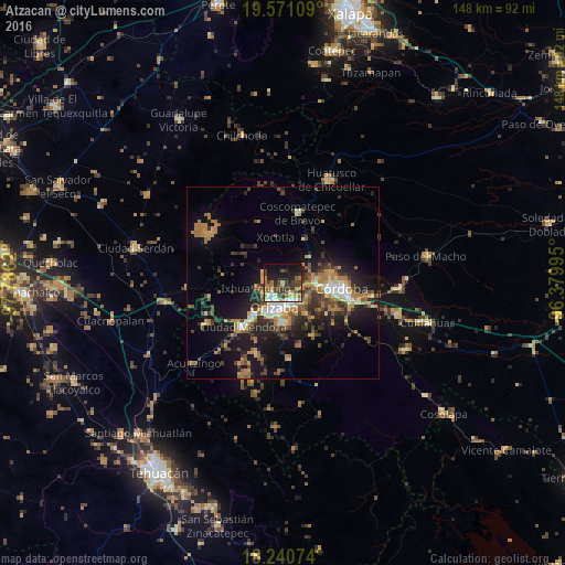
Analysis of Atzacan night lights 2016
Square area 10x10 km:
 3.68%
3.68%90-99
6.93%80-89
4.76%70-79
6.28%60-69
10.39%50-59
5.63%40-49
9.52%30-39
12.34%20-29
10.17%10-19
21.86%0-9
8.44%Square area 50x50 km:
1.24%90-99
1.93%80-89
1.76%70-79
2.57%60-69
4.03%50-59
1.89%40-49
3.51%30-39
3.55%20-29
4.76%10-19
11.65%0-9
63.12%Clear (daylight) street map image can be seen on geolist.org.
Map coordinates:
19° 34' 15.9" North, 97° 47' 10.3" West
18° 54' 26.1" North, 97° 4' 59.1" West
18° 14' 26.7" North, 96° 22' 47.8" West
Some cities around Atzacan sort by population:
• Orizaba
6.4 km =4 mi,  195°
195°
• Ixtaczoquitlán
6.3 km =3.9 mi,  159°
159°
• Fortín de las Flores
8.7 km =5.4 mi,  89°
89°
• Palmira
4 km =2.5 mi,  227°
227°
• Jalapilla
9 km =5.6 mi,  183°
183°
• Unión y Progreso
5.4 km =3.4 mi,  224°
224°
• Cuautlapán
7.1 km =4.4 mi,  117°
117°
• Monte Blanco
9.6 km =6 mi,  46°
46°
3532565 (p: 8,947)
Sources (retrieved 2019-11-25):
» Earth at Night: Flat Maps 2012, 2016