Camargo night lights from space
Night Light of Camargo (Tamaulipas) from space (Mexico) Src. Average luminocity for 10x10km area is 1.3294% and for 50x50km: 8.2683%.
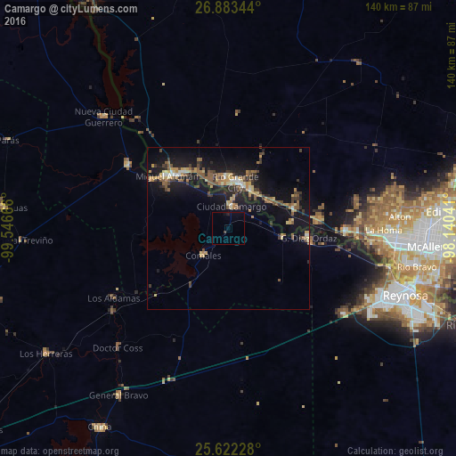
Analysis of Camargo night lights 2016
Square area 10x10 km:
 0%
0%90-99
0%80-89
0%70-79
0%60-69
0%50-59
0%40-49
0%30-39
0.79%20-29
0%10-19
1.19%0-9
98.02%Square area 50x50 km:
0.45%90-99
0.44%80-89
1.29%70-79
1.12%60-69
1.31%50-59
1.98%40-49
1%30-39
1.69%20-29
1.66%10-19
9.23%0-9
79.82%Clear (daylight) street map image can be seen on geolist.org.
Map coordinates:
26° 53' 0.4" North, 99° 32' 48" West
26° 15' 16.5" North, 98° 50' 36.7" West
25° 37' 20.2" North, 98° 8' 25.5" West
Some cities around Camargo sort by population:
• Ciudad Miguel Alemán
24.5 km =15.2 mi,  311°
311°
• Rio Grande City, US
14.1 km =8.8 mi,  9°
9°
• Ciudad Gustavo Díaz Ordaz
24.9 km =15.5 mi,  95°
95°
• Roma, US
24 km =14.9 mi, 314°
• Roma-Los Saenz, US
24 km =14.9 mi, 314°
• Ciudad Camargo
6.7 km =4.2 mi, 8°
• Perezville, US
44.3 km =27.5 mi,  94°
94°
• Doffing, US
45.7 km =28.4 mi, 87°
3531764 (p: 10,085)
Sources (retrieved 2019-11-25):
» Earth at Night: Flat Maps 2012, 2016